Last Updated on September 23, 2025 by foxintheforest
As one of the most ecologically diverse countries on the planet, you’ll never be lost when it comes to finding the best places to hike in the USA.
In fact, there are so many beautiful hikes in the US, you could spend a lifetime tackling trails and still not see them all.
In order to get out there and explore the best hiking in America, it’s always great to have expert advice on your side.
I may be a literal pro at hiking – I write about the topic for major media outlets and brands – but in order to give you the ultimate list of the best places to hike in the US, I enlisted the help of a few experts to help me out.
About this Guide to the Best Places to Hike in the US
When it comes to the most beautiful hiking in the US, I’ve got you covered with this incredibly crafted guide. Here’s what you’ll find inside.
- Info about which state has the best hikes (spoiler: highly debatable)
- How to find the best hikes in the US
- When is the ideal time to go hiking in America
- The most beautiful hikes in America broken down by region
What State Has the Best Hikes?
If you ever want to start a lively discussion, ask which state is best for hiking. The answer largely depends on what kind of hiking you enjoy.
If you’re seeking rugged, remote challenges head to the mountain west to states like Colorado, Wyoming, and Utah or even Alaska.
California, Washington, and Oregon boast amazing mountain hikes as well as easier jaunts, making it suitable for all abilities. But it’s far more crowded than other places on this list.
For fall colors, nothing beats the east coast and the southern Appalachian Mountains. Tropical hiking is amazing in the US territory of Puerto Rico and Hawaii.
For a unique desert experience, nothing in the entire world is quite like the American Southwest (I know – I’ve looked). Uncover unbelievable red rock beauty in Utah, Arizona, and even parts of Nevada.
Finding the Best Hikes in the US
If you’re curious about how to find the best hikes in the US, there are a few easy resources you can use.
- Blogs
- AllTrails
- Take a quick-and-easy hiking course
- Get out and hike!
Blogs and AllTrails will give you a definitive list of trails, but if you want to properly plan and execute a hike, nothing can substitute for a 1-hour course on finding and planning a hike.
Then the next step is to get out and hit the trails! The more you hike the better you’ll be at finding amazing places to hike in the US. And you never know, you might just discover the next most beautiful hike in the US.
Pro Tip: Social media is great, but it often doesn’t include information about how crowded a place was, how tough permits were to get, or how authentic the experience is.
Personally, I never use socials to find hikes and instead stick to trails that I find on my own.
When is the Best Time to Hike in the USA?
Thanks to spanning 10 different climate zones, you can hike year-round in the US. You just need to know where to go!
Winters can be tough since many of the most beautiful hiking trails in America are covered in snow. Some may even be dangerous. Stick to warm places to visit in the US during winter, such as Arizona, Hawaii, Florida, even Southern Texas for hiking.
Spring can be a beautiful time in desert locations. While summers are perfect for hiking in the mountains. Fall is prime time for desert hiking and exploring forests which burst to life with colorful leaf displays.
Best Places to Hike in the USA: West Coast
Arguably the most famous place to find the best hiking in the US, the west coast has incredible opportunities for hiking.
Just keep in mind that many of the most popular hikes in the US require advanced permits in order to hit the trails.
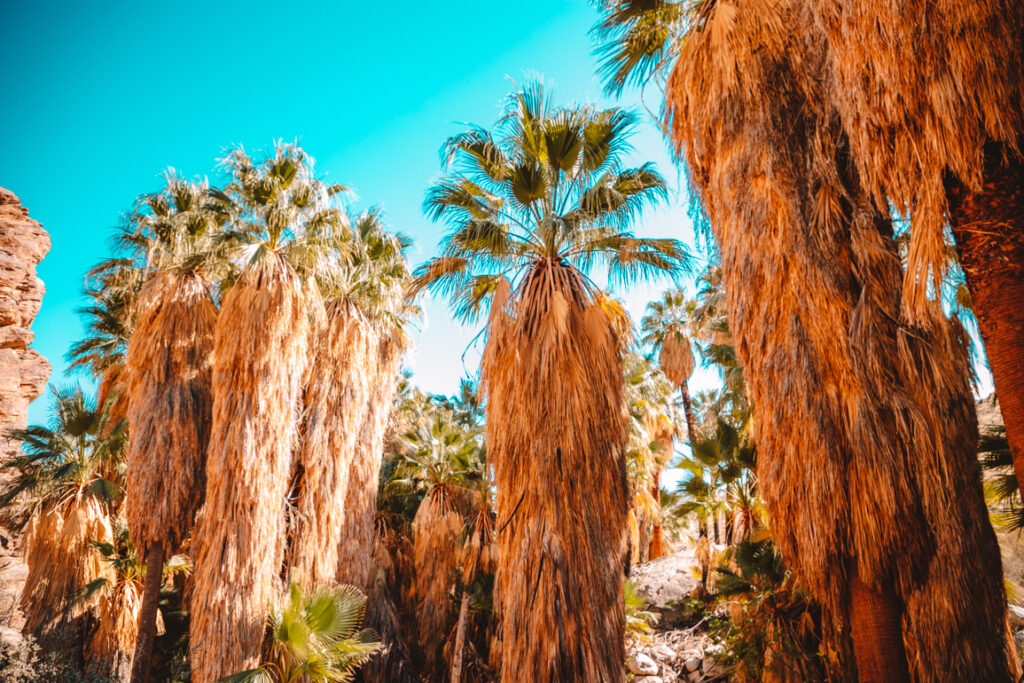
1. Indian Canyons, Palm Springs, California
Recommended by Kara Harms from Whimsy Soul
Right outside the city of Palm Springs are Indian Canyons, a large pal-filled nature preserve with over 60 miles of hiking trails.
It’s a little oasis in the desert that is one of the best places to hike in the USA,. In fact, it’s so unique there are no other spots like this in the US.
Hikers can choose from a number of trails, some lined with palm trees next to a creek, others leading to secret waterfalls you can go swimming in.
On a hotter day when a long hike is out of, Andreas Canyon Trail is the best option. It’s 1.2 miles, has minimal elevation gain, and runs along a creek which keeps the climate a bit cooler.
That being said, Palm Springs area can reach over 120 degrees in the summer, so if hikers plan on coming in June-August, they should arrive very early to avoid the hottest hours and pack extra water.
Indian Canyons sits on Agua Caliente Band of Cahuilla Indians land and requires a $12 fee to enter. Inside, there are many parking areas at the start of each major trailhead.
Most of the parking areas have tons of picnic benches so pack a lunch and plan on feasting under hundreds of palm trees.
Practical info
Distance: Trails ranging from 1.2 miles to 12.3 miles
Difficulty: Varies by trail
Estimated Time: 45 minutes to 6 hours
Elevation Gain: Trails range from 200 feet to 1500 feet elevation gain.
Red Tape: Fee is $12 per adult. Dogs are not allowed. Horses are allowed on horse trails.
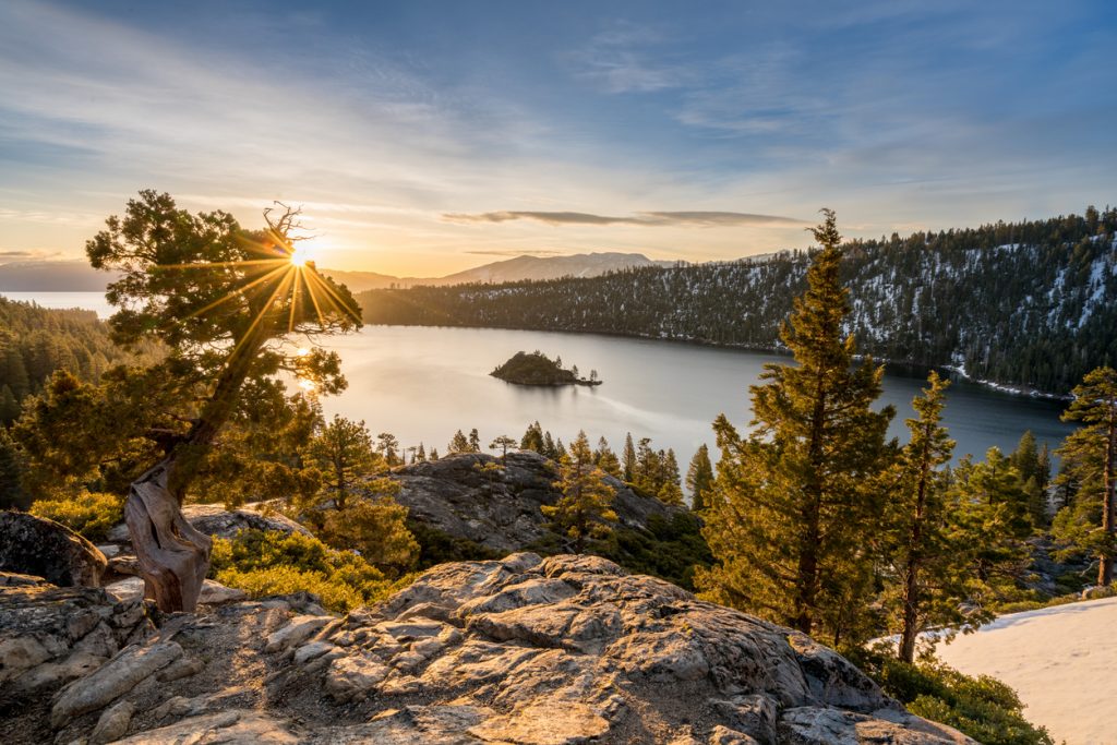
2. Emerald Bay Lake Tahoe, California
For jaw-on-the-floor alpine views, there is no other place like Emerald Bay in Lake Tahoe. It’s called Emerald Bay for a reason, as the waters glitter like an Emerald on a sunny day.
This area offers some of the best Lake Tahoe views and shouldn’t be missed. Located on the California side of the lake, the Emerald Bay hike is a must-do in your lifetime.
Several different options for hiking exist along these gem-colored waters. Beginners or those short on time should take the easy-easy Emerald Bay Trail – a 0.5-mile rim trail that delivers all the delicious views.
For an aerial approach, hike the Eagle Falls Trail to catch a bird’s eye glimpse of the lake along this 1.9-mile easy hike.
Hikers who want all-day action should jump on the Rubicon Trail a 10.2 to 16-mile round-trip hike that circumnavigates the coastline of Emerald Bay. As one of the most beautiful hikes in Lake Tahoe, this trail sees plenty of traffic, so snag an early start.
It’s $5 to park and on weekends parking will fill up before 7:30 am. So plan accordingly.
Local Tip: The road can close in the winter, although seeing the place dusted in snow is unreal. Sunrise is the best time to visit Emerald Bay if you want any chance at solitude.
Practical info
Distance: 0.5 to 16 miles
Difficulty: Very easy to challenging
Elevation Gain: 100 feet to 1,090 feet
Estimated Time: 15 minutes to 8 hours
Red Tape: $5 parking fee, no dogs on the Rubicon Trail
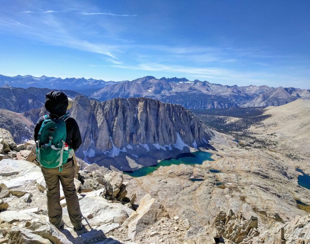
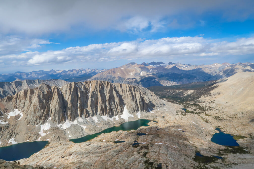
3. Mount Whitney Trail in Sequoia National Park
Recommended by Jackie and Justin from Life of Doing
Mount Whitney, located within Sequoia National Park and Inyo National Forest and nearby the town of Lone Pine, is one of the most challenging hikes in California and one of the best places to hike in the USA.
It’s the highest mountain in California and the contiguous United States at an altitude of 14,505 feet high.
The trail is open all year, but it gets snow and ice in the wintertime. The best time to visit is from July to late September. This trail also connects with the John Muir Trail for those doing an extended trek.
This hike requires some planning. Everyone must participate in a lottery from February to mid-March for an overnight or one-day permit on a chosen date.
You’ll get notified of the hiking date in April and must pay $15 per person. Permits may be printed one week before the hike or picked up at the Visitor Center.
A one-day hike on Mount Whitney is possible, but it’ll be challenging. Two days is better for better altitude acclimatization and staying overnight at one of the campsites in the National Forest.
The hike starts at Whitney Portal and then you walk through the forest area. You’ll reach the 99 switchback areas and you can see the sunrise here.
You’re almost at the top of the peak when walking through the granite mountains.
At the peak, you’ll get some beautiful views of the area. The peak is chilly and windy so rest at the stone hut and refuel before heading back down.
Take lots of breaks on your way down as your legs will be tired by now.
Practical info
Distance: 22 miles round trip
Difficulty: Difficult
Elevation Gain: 6,200 feet
Estimated Time: 13 hours to 2 days
Red Tape: An overnight or day trip permit is required to hike this trail. Dogs are not allowed in the wilderness area of the National Park but are allowed in the National Forest.
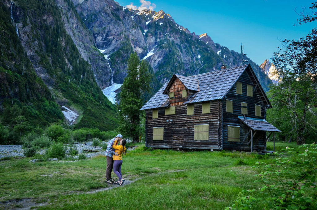
4. Enchanted Valley Trail, Olympic Peninsula, Washington
Recommended by Katie and Ben from Go Wander Wild
Known as one of the best hikes in the Olympic National Park, the Enchanted Valley Trail brings you through lush old-growth forests, across rustic bridges scaling the Quinault River, and ultimately to a majestic wide open valley on Washington’s Olympic Peninsula.
This moderately challenging hike covers 27 miles in total and typically takes hikers 2 days to complete the out-and-back journey.
The main draw of the trail is near the end of Day 1 when the trees open up a bit and you are rewarded with sweeping views of the snow-capped peaks and river running through the Enchanted Valley.
It would be a shame to turn around before you reach this incredible vista in one of the best places to hike in the USA.
Aside from nature and wildlife, one of the highlights on the trail is the iconic Enchanted Valley Chalet.
This historic building was erected in 1931 as accommodation for hikers along the trail but was turned into a lookout for Japanese planes during WWII.
Nowadays the chalet is boarded up so you can no longer enter but still stands as a nice photo backdrop for hikers in the area.
The best time to hike the Enchanted Valley Trail would be from May to October when you have a better chance of warm and dry weather on the Olympic Peninsula.
You can reserve your permit for overnight camping at Recreation.gov. It’ll cost you $8 per person, per night, plus a $6 non-refundable reservation fee.
Try to secure your permit early in the season or (at least) several weeks before you plan to do the hike as permits do sell out.
Practical info
Distance: 27 miles
Difficulty: Moderate
Elevation Gain: 1,400 ft
Estimated Time: 2 – 3 days
Red Tape: Dogs are not allowed on this trail, you will need an Olympic National Park wilderness permit if you plan to camp overnight (recommended).
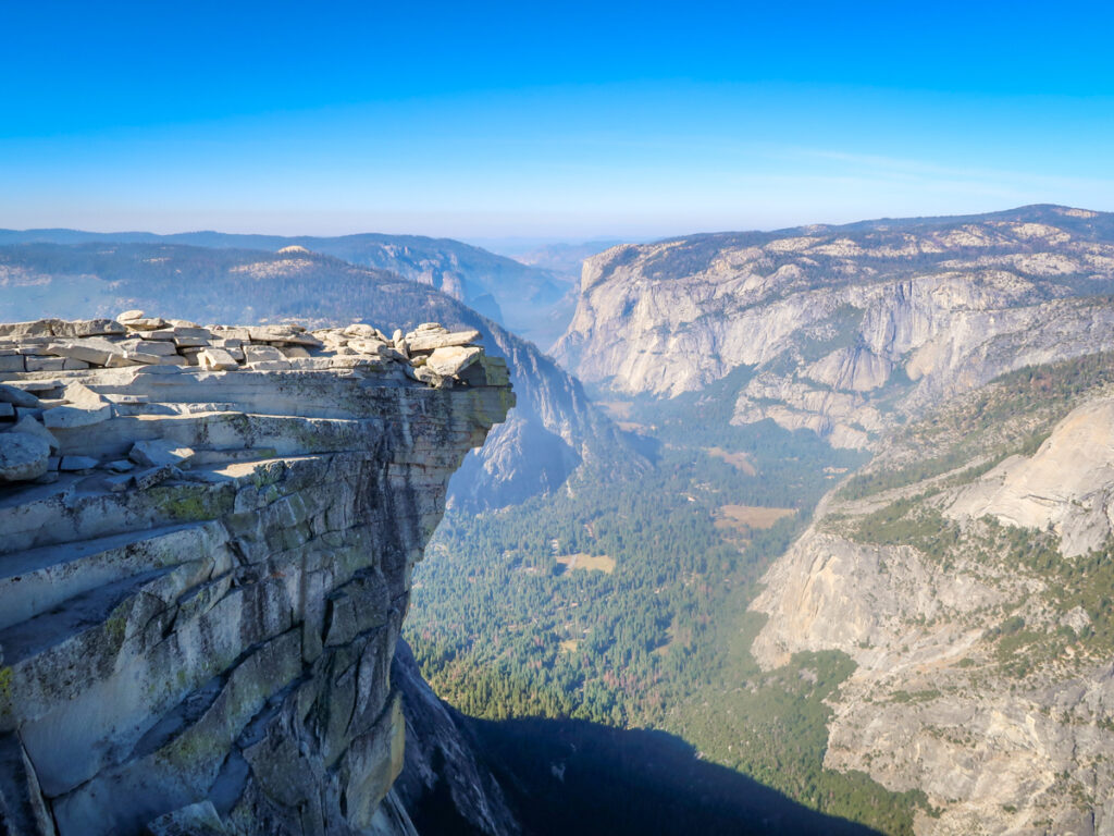
5. Half Dome, Yosemite National Park
Recommended by Katy from A Rambling Unicorn
If you’re looking for some of the best hiking in the US, you can’t beat Half Dome in Yosemite National Park.
One of Yosemite’s most iconic features, Half Dome is a granite formation that towers over the park and is visible from miles away.
This challenging trail is 15 miles long and typically takes 10-12 hours to complete in a single day. The final push to the top involves ascending near-vertical cables for 400 feet.
The views from the top are worth the effort, however. Climbing the Half Dome cables is an exhilarating (albeit somewhat terrifying) experience that makes reaching the top all the more satisfying.
The Half Dome hike begins by following along the Mist Trail. Highlights of the trek include the spectacular Vernal Falls (317 feet) and Nevada Falls (594 feet).
After passing Little Yosemite Valley Campground, hikers continue until reaching the base of the sub dome before scaling the cables to the top.
One of the hardest parts about climbing Half Dome is getting a permit. These are distributed by lottery and can be rather hard to come by since this is trail is home to some of the best hiking in America.
Those hikers lucky enough to score permits should bring gloves (for the cables) and a headlamp (in case the hike takes longer than planned).
Pro tip: if you can’t get a single-day permit, try going for a backpacking permit instead. Camping at Little Yosemite Valley Campground is a great way to break the hike into shorter chunks for those who can’t hike 15 miles in a single day.
Practical info
Distance: 15 miles there-and-back
Difficulty: Difficult
Elevation Gain: 5193 feet
Estimated Time: 10.5 hours
Red Tape: Permit is required in addition to Yellowstone entrance fee; no dogs allowed.
6. Pacific Crest Trail
Recommended by Katy from A Rambling Unicorn
The Pacific Crest Trail (PCT) is an epic long-distance footpath with gorgeous alpine scenery in the western United States and is home to some of the most beautiful hiking in the US.
Stretching from Mexico to Canada along the spine of the Sierra and Cascade mountain ranges, the PCT is one of the few hikes designated as a National Scenic Trail in the USA.
The trail spans three states along with a range of landscapes and ecosystems that make for some of the best places to hike in the USA.
In California, the PCT travels through the Mojave Desert and the spectacular High Sierra mountains – where the trail reaches its highest point of 13,153 feet.
Oregon highlights include Crater Lake and Mount Hood. In Washington, hikers journey through the stunning Goat Rocks Wilderness in the Cascade Mountains before reaching Canada.
Those who attempt the entire trail in a single season are called thru-hikers. This is a difficult undertaking and typically takes 5-6 months with an average of 20 miles per day.
Most northbound thru-hikers start in April/May and must finish in September/October before the autumn snowstorms begin.
Of course, not everyone on the Pacific Crest Trail is a thru-hiker. Thousands of people each year hike shorter sections of the trail as a day hike or on a backpacking trip.
The trail is managed by a variety of organizations and some areas require permits. Thru-hikers should apply for a long-distance permit from the Pacific Crest Trail Association along with a special permit to enter Canada on foot.
While dogs are permitted in some sections of the PCT, most pups cannot handle the rigors associated with a thru-hike and typically remain at home.
Practical info
Distance: 2650 miles
Difficulty: Difficult
Elevation Gain: 489,400 feet (northbound)
Estimated Time: 6 months, or shorter if you’re just hiking certain sections
Red Tape: Permits required for certain sections; dogs are not allowed in some areas.
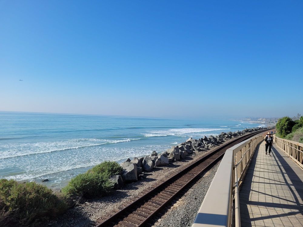
7. San Clemente Beach Trail
Recommended by Trijit Mallick from Dog Travel Buff
Located in Southern California, San Clemente Beach Trail is an easy but scenic flat trail that offers an amazing view of the coastline and train tracks.
There are various access points to this trail. It is a free hiking trail but parking varies at different trailheads. You can park your car at the North Beach or Calafia State Park (south trailhead where parking is more expensive).
If you start your hike from the North Beach parking lot, head towards the south and enjoy a nice walk through this well-maintained trail and beautiful flowering succulents along the path.
The unique thing about this trail is that it offers some areas where you can cross the rail tracks, watch the Amtrak passing along the shoreline.
You get some amazing views of the ocean and enjoy the nice cool breeze to go with it, making it one of the best places to hike in the USA.
Some parts of the trail are paved, and others parts are sand, but the shade is limited.
You can hike San Clemente Trail at any time of the year. If you hike this trail in the summer, make sure to bring a lot of water. However, spring and winter is the best time to hike this trail.
It’s one of the most beautiful dog-friendly hikes in Orange County. Pet owners can walk, jog with their four-legged friends. You can also ride your bikes on it.
The trail widens near the per where you can enjoy a meal with the fresh ocean air and explore the shopping stores.
Practical info
Distance: 4.5 miles
Difficulty: Easy
Elevation Gain: 55 feet
Estimated Time: 2 hours and 15 minutes
Red Tape: Dogs must be leashed.
Best Places to Hike in the USA: Midwest, Southern and Eastern US
A lot of people pass by the midwest and eastern seaboard when it comes to hiking, but that would be a mistake. Some of the most beautiful hiking rails in the US can be found in gorgeous pockets of these regions.
What’s awesome about these hikes is you’re not contending with super-high elevations or a sea of confusing permits to hike.
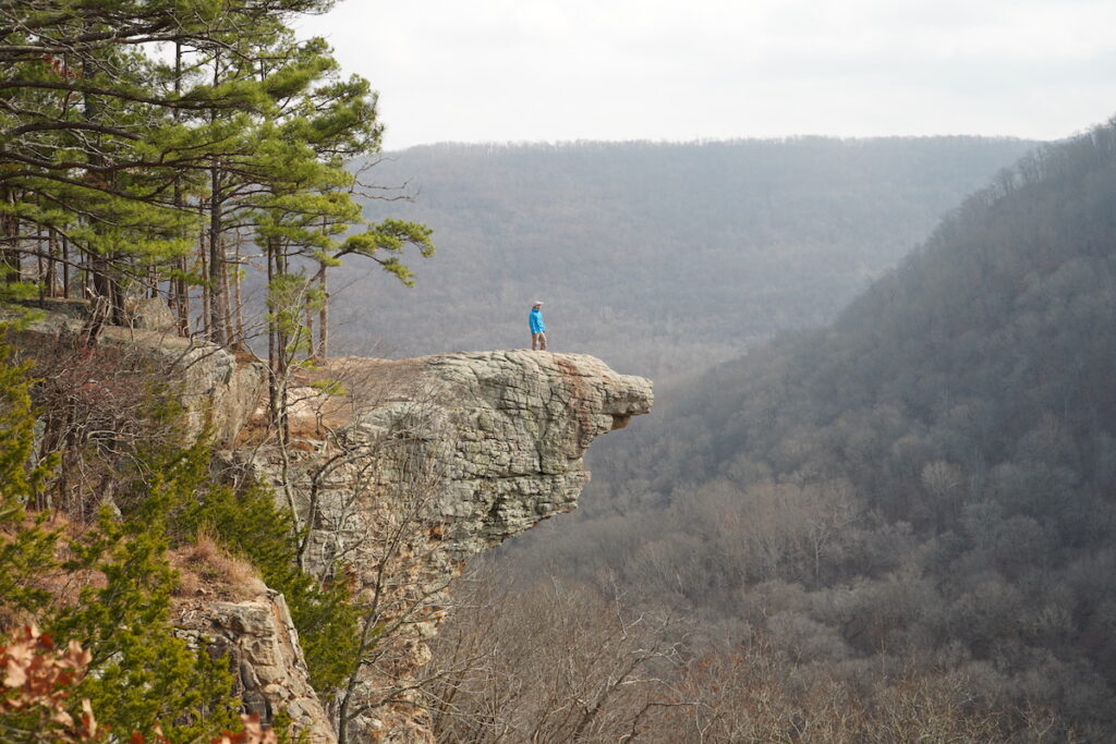
8. Whitaker Point Trail to Hawksbill Crag, Ozarks, Arkansas
Recommended by Ashlee Fechino from The Happiness Function
Hiking the Whitaker Point Trail to Hawksbill Crag is one of the most iconic hikes in Arkansas.
Tucked within the Ozark Mountains of northwest Arkansas, there is something special about the forest’s energy here that makes it one of the best places to hike in the USA.
Along with being a fantastic place to get out in the Ozarks, the Whitaker Point Trail is easy to hike, there is a little waterfall to see (if the water is running), and there are incredible views of the mountains.
In addition, the Hawksbill Crag is a popular place to photograph.
The best time to visit is during the middle of the week to beat the crowds. This is an extremely popular hike, and if you want to get solo pictures on the crag, do not visit on the weekends.
Hikers can hike this trail year-round. During the fall, the weather is cooler, and you can see the leaves changing.
The forest is greening up in the spring, and the weather is still cool. Summers are humid but still incredibly lush and beautiful.
The trail is 2.9 miles out and back with an elevation gain of 413 feet, so relatively easy by most hiking standards.
However, there are steep bluffs along the trail which may provide just an edge of a challenge for hikers. Overall, the trail is well marked and easy to follow.
Dogs are allowed on the trail so bring your furry friends!
There are no permits or fees to hike the Whitaker Point Trail, making it a great choice for a stress-free day out. Be sure to add this epic hike to your list of the best places to hike in the US!
Practical info
Distance: 2.9 miles
Difficulty: Easy/Moderate
Elevation Gain: 413 feet
Estimated Time: 1.5 hours
Red Tape: None
9. Appalachian Trail
Recommended by Bret Love and Mary Gabbett from Blue Ridge Mountains Travel Guide
Stretching nearly 2,000 miles from Springer Mountain in North Georgia to Baxter State Park in Millinocket, Maine, the Appalachian Trail is arguably the most epic hiking trail in the USA.
Approximately three million people hike at least some portion of the trail every year. And while some 3,000 people gear up annually in the spring to attempt a thru-hike of the entire AT each year, only 25% of them actually complete the entire route.
It’s considered one of the most beautiful and grueling hikes in America, requiring extreme physical and mental stamina as well as dogged determination to conquer some of the most beautiful hiking in the US.
The arduous journey takes most hikers 6 to 8 months to complete because the terrain is mountainous for its entire length, with a total elevation gain and loss that’s equivalent to hiking up Mount Everest from sea level and back 16 times. Wowza!
Hiking it from north to south is generally considered the most difficult due to the climate in Maine, and the southern end can be very crowded in Spring.
So it’s becoming increasingly common to start somewhere in the middle (around Harpers Ferry, WV or Virginia’s Shenandoah National Park), complete the northern half, then head back to where you began and complete the southern section.
But most people choose to day-hike smaller portions of the trail, which is a great way to get a taste of the majestic mountains, waterfalls, wildlife, and far-reaching scenic vistas that are one of the best places to hike in the USA is known for.
The Appalachian Trail in Georgia and North Carolina are especially beautiful, taking hikers through gorgeous stretches of the Chattahoochee National Forest, Nantahala National Forest, and Great Smoky Mountains National Park.
From Spring Mountain and Blood Mountain in Georgia to Clingmans Dome and Max Patch, day-hiking these southern AT sections offers an extraordinary chance to see the highest mountains in the eastern US without making a 6 to 9-month commitment.
Practical info
Distance: 2,162 miles
Difficulty: Difficult
Elevation Gain: Roughly 515,000 feet over the total length of the trail
Estimated Time: 6 to 9 months
Red Tape: No fees for the AT, but the trail passes through numerous state and national parks, forests and public lands. Some of these charge fees or require permits or reservations if you want to park or stay overnight in shelters or campsites. Dogs are allowed everywhere on the Appalachian Trail except in Great Smoky Mountains National Park (TN/NC), the Trailside Museum & Wildlife Center in Bear Mountain State Park (NY), and Baxter State Park (Maine).
10. South Rim Trail, Big Bend National Park
Recommended by Ketki of Enchanting Texas
Looking for one of the best hikes in the US? If so then head to Big Bend National Park in Texas and try the amazing, South Rim Trail.
After all, Big Bend is one of the best places to visit in Texas and is home to this amazing hiking spot.
Come prepared though since this is a challenging, 12.5-14-mile loop hike that results in about 2,000+ feet of elevation gain.
This hike will also take around 8 hours to complete, depending on your level of fitness.
Therefore, you may want to do this as a multi-day hike since there are plenty of backcountry campsites along the route.
Other than that, start at the Basin trailhead and enjoy this fun, backcountry hike along rugged terrain.
About halfway through, you’ll marvel at stunning panoramas from the South Rim and can then ascend either via the steeper Pinnacles or by way of the more gradual Laguna Meadows Trail.
Just be aware that during Peregrine Falcon nesting season Northeastern and Southeastern sections of the trail may be closed to the public.
Practical info
Distance: 12.5 miles
Difficulty: Difficult
Elevation Gain: 2,857 feet
Estimated Time: 6.5 hours
Red Tape: $30 per vehicle day-use fee and dogs are not allowed.
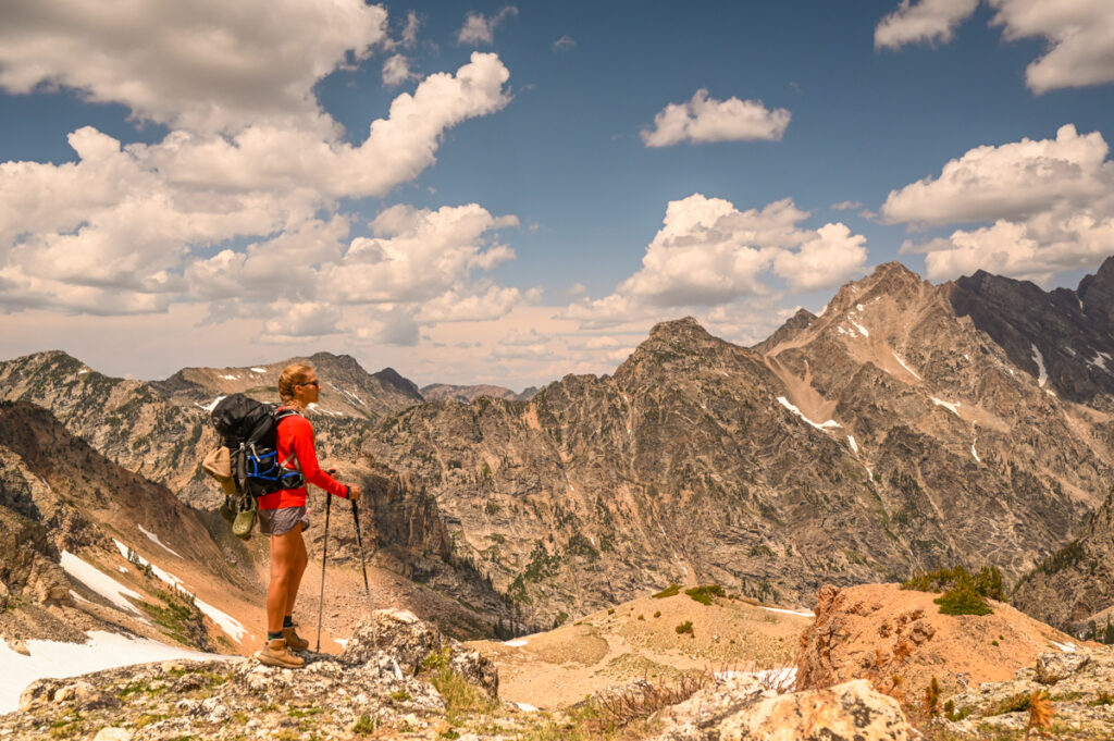
Top USA Hikes: Mountain West
Known for its rugged mountain landscapes and high-altitude hikes, the Mountain West is a literal hiker’s playground. Seriously, some hikes feel more like jungle gyms than actual hiking.
You may be huffing for oxygen in the thin mountain air or having your breath taken away by stunning scenery with these top places to hike in the US.
11. Dream and Emerald Lake in Rocky Mountain National Park, Colorado
As one of the most beautiful hikes in Colorado, everyone needs to put the Emerald Lake hike on their list.
This incredible (and relatively easy) hike takes you through jaw-dropping mountain landscapes where rugged peaks meet tranquil alpine lakes.
This 3.6-mile out-and-back trail features four distinct alpine lakes, each one more breath-taking than the last.
During late June and July, enjoy fields of colorful wildflowers as you wind your way through fairytale pine forests.
The trail starts at the famous Bear Lake Trailhead in Rocky Mountain National Park. Simply follow signs for Dream Lake and Emerald Lake.
You’ll wind through several different landscapes as you stumble across four distinct lakes (Bear Lake, Nymph Lake, Dream Lake, and Emerald Lake).
This is an extremely popular hike, so start well before dawn with a headlamp if you want any chance of beating the crowds.
Local Tip: As one of the top hikes in Rocky Mountain National Park, you’ll need an advanced timed entry permit for the Bear Lake Trailhead in addition to park fees.
Distance: 3.6 miles
Difficulty: Easy to moderate
Elevation Gain: 702 feet
Estimated Time: 1.5 to 2 hours
Red Tape: No dogs. Advanced timed entry permit required for the park. Get there before sunrise if you want to be able to park in the parking lot. Otherwise, you’ll need to catch a ride on the shuttle.
12. Hanging Lake in Colorado
Arguably one of the most beautiful Colorado lakes, Hanging Lake is a true icon. You won’t believe your eyes as you wind your way up to this tranquil lake in the sky.
The calm waters and trickling waterfalls might make you think that fairies live here.
Although the trail is steep by most standards, this hike is easy by Colorado standards. There are plenty of benches and railings to help you up the steep canyon walls along the way.
As one of top things to do in Glenwood Springs, the Hanging Lake hike requires an advanced permit. For the best chance at solitude, select a 6 am slot during the week.
Once you reach the top, the views are well worth the effort. During the springtime, it’s worth it to stop at Spouting Rock, one of the most unique waterfalls in Colorado.
Local Tip: As of 2021, this trail is closed until further notice due to catastrophic landslides. Don’t worry, as one of the prettiest places in Colorado, it is scheduled to re-open on June 25th, 2022.
Practical info
Distance: 3.1 miles
Difficulty: Easy to moderate
Elevation Gain: 1,187 feet
Estimated Time: 1.5 to 2 hours
Red Tape: No dogs. Advanced timed entry permit required. No swimming, no drones, and no fishing.
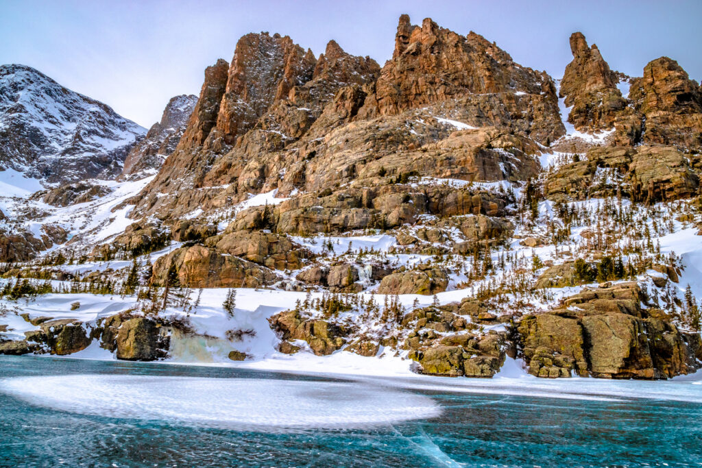
13. Sky Pond Rocky Mountain National Park, Colorado
When it comes to alpine lake hikes in Colorado, Sky Pond takes the cake. Situated inside of the stunning Rocky Mountain National Park – one of the best national parks for hiking in the US – countless hikers come to reach this glistening lake in the sky.
In order to reach Sky Pond, you’ll have to hike through forests, past beautiful mountain cirques and up challenging switch backs.
The end of the hike is the hardest, as you’ll be hiking across and over a steep waterfall to reach the Lake of Glass. Be prepared to use your hands and watch your footing.
Once you reach the Lake of Glass, you’re almost there. Keep going to reach the infamous Sky Pond. Surrounded by impossibly tall spires of gneiss and granite, this oasis in the clouds brings you face to face with serious mountain drama.
You’ll need a special advanced timed entry permit for the Bear Lake Corridor (the same one as Emerald Lake) in order to park at the parking area.
Park at Glacier Gorge for the quickest hike, or you can park at Bear Lake and add about 3 miles to your journey.
Keep in mind that this is also the starting point for some of the top climbing areas in Colorado, and alpinists start their day by 2 am. This means that the limited parking lot fills up by 3 am or 4 am during the summer months.
Practical info
Distance: 8.1 miles
Difficulty: challenging
Elevation Gain: 1,765 feet
Estimated Time: 3 to 4 hours
Red Tape: No dogs. Advanced timed entry permit required for the park. If you can’t park, you’ll need to take the shuttle.
14. Paintbrush Canyon Cascade Canyon Loop, Grand Teton National Park
Recommended by Sarah and Matt from Two Outliers
The Paintbrush Canyon Cascade Canyon Loop is perhaps the best hike in Grand Teton National Park, featuring sweeping mountain vistas, numerous stunning alpine lakes, and a great chance to see wildlife.
Covering nearly 22 miles and 4200 feet of elevation gain, the Paintbrush Canyon Cascade Canyon Loop is a very challenging day hike or an overnight adventure (backcountry permits required for 2 day stays)/
Many hikers opt to split the hike up over two days, completing the loop as a one-night backpacking trip in one of the best places to hike in the USA.
Because the Paintbrush Canyon Cascade Canyon Loop takes you deep into the backcountry of the Grand Tetons, it offers the perfect chance to escape the crowds and find solitude in this busy national park.
The highlight of the hike is Paintbrush Divide, an alpine pass standing at 10,700 feet with sweeping 360-degree views over Paintbrush Canyon to the east and the North Fork of Cascade Canyon to the southwest.
Additionally, the trail includes several other popular Grand Teton landmarks, such as Holly Lake, Inspiration Point, Hidden Falls, Jenny Lake, and Lake Solitude.
Snow is still likely at higher elevations in Grand Teton during the early summer, so the best time to hike the Paintbrush Canyon Cascade Canyon loop is from mid-July through early September. Prior to July, Paintbrush Divide is typically not safe to pass.
Practical info
Distance: 21.9 miles
Difficulty: Difficult
Elevation gain: 4,200 feet
Estimated Time: 2 days
Red Tape: $35 entrance fee per vehicle (good for 7 days), or $85 annual U.S. National Parks Pass. No dogs. Permits are required for overnight backpacking trips, but not for day hiking.
Amazing Places to Hike in the USA: American Southwest
There is nothing else on this planet like the American Southwest. The weird and whacky sandstone landscapes formed by millennia of rain, wind, and sand create landscapes that are simply out of this world.
Although you won’t find yourself huffing and puffing without air here, hiking in the desert presents its own set of unforgiving conditions.
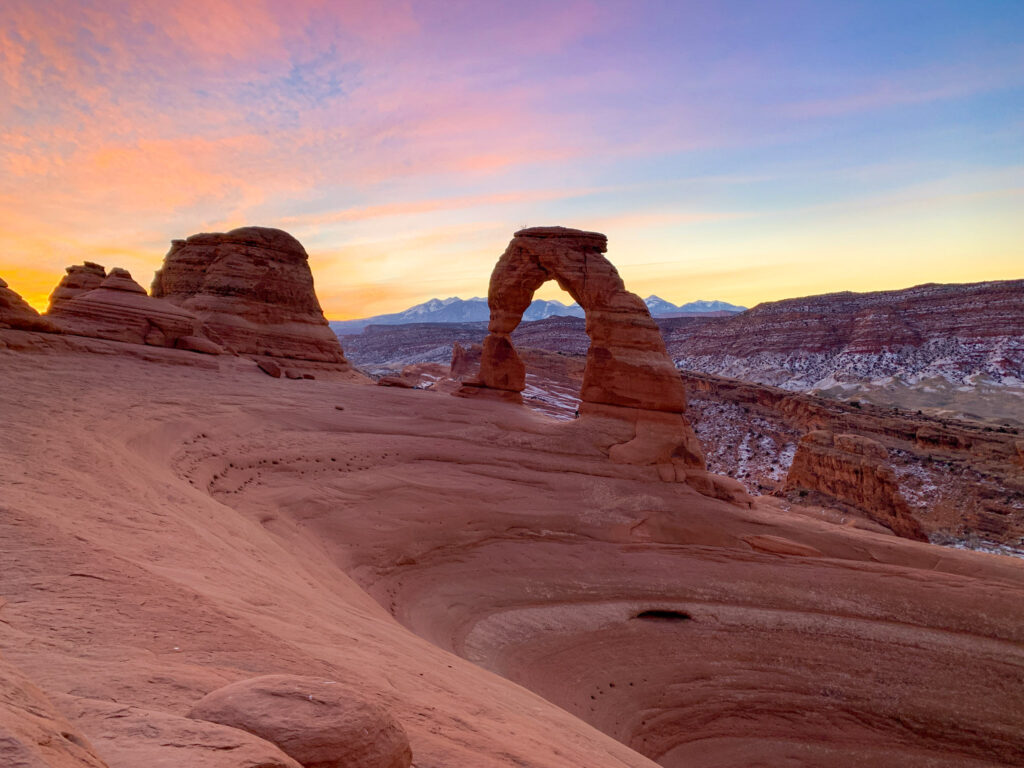
15. Delicate Arch in Arches National Park
Okay, so this may just be the most famous of all the best hikes in Utah, but Delicate Arch in Arches National Park is certainly worth a trip.
Although it has a couple of steep sections, it’s a relatively easy desert hike, making it accessible for all abilities.
Make your way along the well-marked trail from the parking lot, up and over a huge petrified sand dune until you reach the famous Delicate Arch.
This hike gets crowded – we’re talking lines of people crowded – so hike Delicate Arch for sunrise in order to beat the biggest crowds.
There are plenty of other amazing, easy hikes in Arches National Park to enjoy nearby, so getting an early start just means you’ll be one step ahead of the crowds during your day in Arches.
Practical info
Distance: 3 miles
Difficulty: Easy to moderate
Elevation Gain: 610 feet
Estimated Time: 1.5 hours
Red Tape: No dogs. No drones
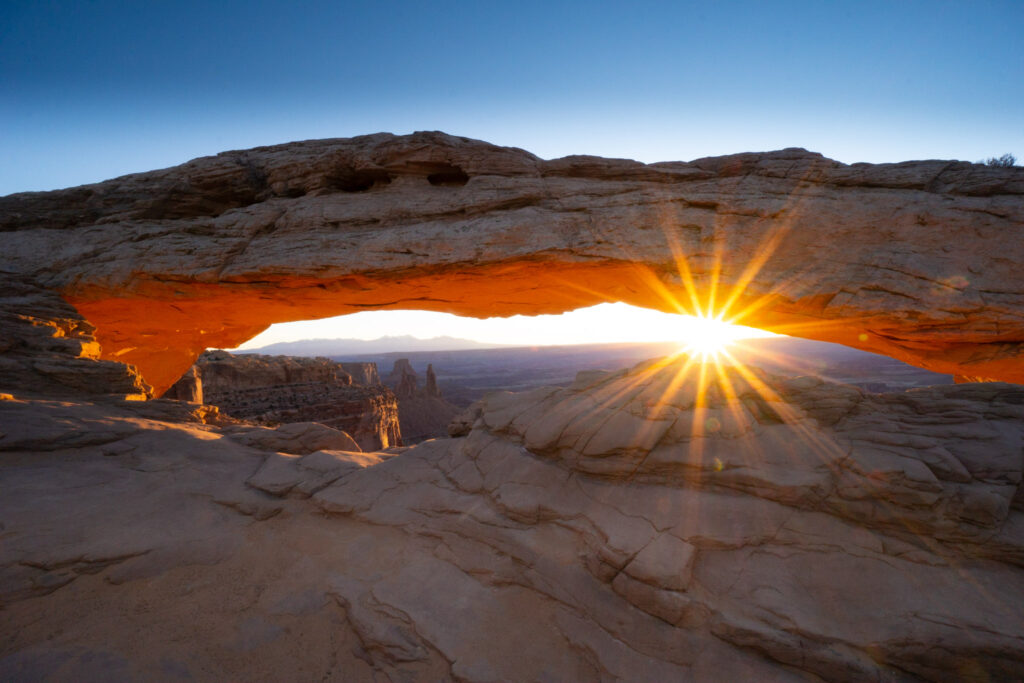
16. Mesa Arch in Canyonlands National Park
Photographers rejoice! The unique morning phenomenon you can find at Mesa Arch for sunrise will have you hauling in all of your favorite camera gear.
Each morning the sun rises underneath this gorgeous rim-side arch, creating a delightful scene that’s one of the most photographed places in the USA.
Located in the Island in the Sky District of Canyonlands, this easy 0.7-mile hike to the canyon rim delights you with stunning views of the intricate canyon systems of the park.
If you’re planning to snag a top spot for sunrise, you’ll want to arrive hours before the sun starts to lighten the horizon. For hikers that just want to view the arch, consider going during the day, when the crowds have thinned.
As one of the top hikes Canyonlands, you can’t miss Mesa Arch.
Practical info
Distance: 0.7 miles
Difficulty: Very easy
Elevation Gain: 65 feet
Estimated Time: 30 minutes to hike, several hours to photograph
Red Tape: No dogs. $30 entrance fee to enter the park.
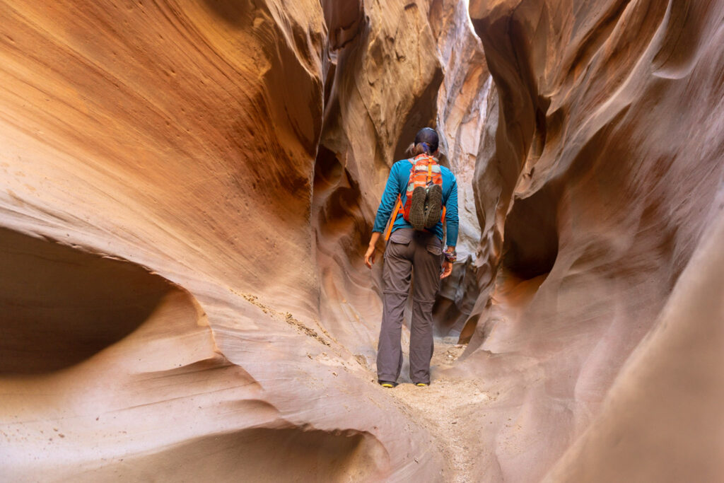
17. Spooky and Peak-a-Boo Slot Canyon in Escalante
Arguably one of the best slot canyons in Utah, the Spooky and Peak-a-Boo hike certainly makes the list for the top hikes in the US. This weird and wonky red rock canyon hike takes you through a maze of increasingly narrowing canyon walls.
At a certain point, you’ll need to take off your pack and scootch sideways to squeeze through the narrows. Scrambling (using your hands to climb up rocks) is required along this winding trail.
Overall, it’s an easier hike, with areas that can prove to be quite challenging if you’re afraid of heights.
First, you’ll need to climb up about 10 feet of rock just to access Peak-a-Boo Canyon. Descending into the depths of Peak-a-Boo Canyon does require using a permanently fixed rope to reach the bowels.
So if you’re looking for a true desert adventure, look no further than this classic slot canyon combo.
Practical info
Distance: 4.5 miles
Difficulty: moderate
Elevation Gain: 633 feet
Estimated Time: 2 to 2.5 hours
Red Tape: Not dog friendly. Hole in the Rock Road en route to the trailhead is impassible when wet. An SUV is recommended due to a long stretch of bumpy dirt road. Check the weather, flash floods can happen even during light rain in canyons and they will kill you.
18. Wire Pass to Buckskin Gulch Near Page, Arizona
The Wire Pass to Buckskin Gulch hike is an incredible, easily-accessible hike in Arizona that can be as long or as short as you’d like.
This sandy-bottom slot canyon doesn’t require any special skills. Buckskin Gulch also happens to be the longest known slot canyon in the world at over 15 miles long, making this one of the best hikes in Kanab.
The easiest way to access Buckskin Gulch is through a small side canyon called Wire Pass. You’ll reach an obvious junction with petroglyphs (and unfortunately graffiti). From here you can opt to explore up canyon or down canyon for as long as you’d like.
Pro Tip: Down canyon has slightly better features and views. Many people opt to backpack the entirety of Buckskin Gulch, but you’ll need an overnight backpacking permit.
Practical info
Distance: 3.7 to 8 miles, or 15 miles one-way
Difficulty: Easy to moderate
Elevation Gain: varies, but not that much
Estimated Time: 2 to 4 hours
Red Tape: $7 fee per person and per dog that must be purchased in advance (the WiFi kiosk at the trailhead doesn’t work).
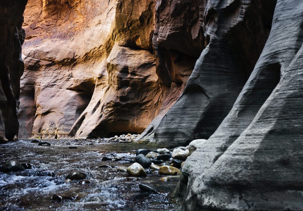
19. The Narrows in Zion National Park
Recommended by Candice from CS Ginger
One of the best hikes in Zion National Park is the Narrows. It is a beautiful slot canyon that is definitely one of the best places to hike in the USA.
The Narrows is a 15-mile section where the Virgin River has carved its way through the rock.
The 16-mile hiking trail runs through the North Fork of the Virgin River. This hike takes a day or two depending on how you do it. If you hike from the top down it is a long day hike or an overnight hike. If you hike from the bottom-up it is a day hike.
The Narrows is closed from mid-March to mid-May when the water levels are the highest from the snowmelt. Summer and fall are the best time to hike this trail.
During the summer, the shuttle runs until 9 pm giving you plenty of time to hike but this is when the trail is the most crowded and more difficult to get a permit.
In the fall, the crowds are smaller, and you can catch some of the fall foliage coming through. An earlier sunset and earlier shuttle times cut your hiking time down by about two hours though.
In order to hike from the top down, you will need a permit. Reservations are allowed up to 2 months in advance on the National Park Service website.
There are only 12 campsites along the trail so there are that many permits handed out daily.
Dogs are not allowed on this trail.
Practical info
Distance: 16 miles
Difficulty: Moderate to Difficult
Elevation Gain: 1,500 feet
Estimated Time: 8 hours
Red Tape: Zion National Park Entrance fee of $30
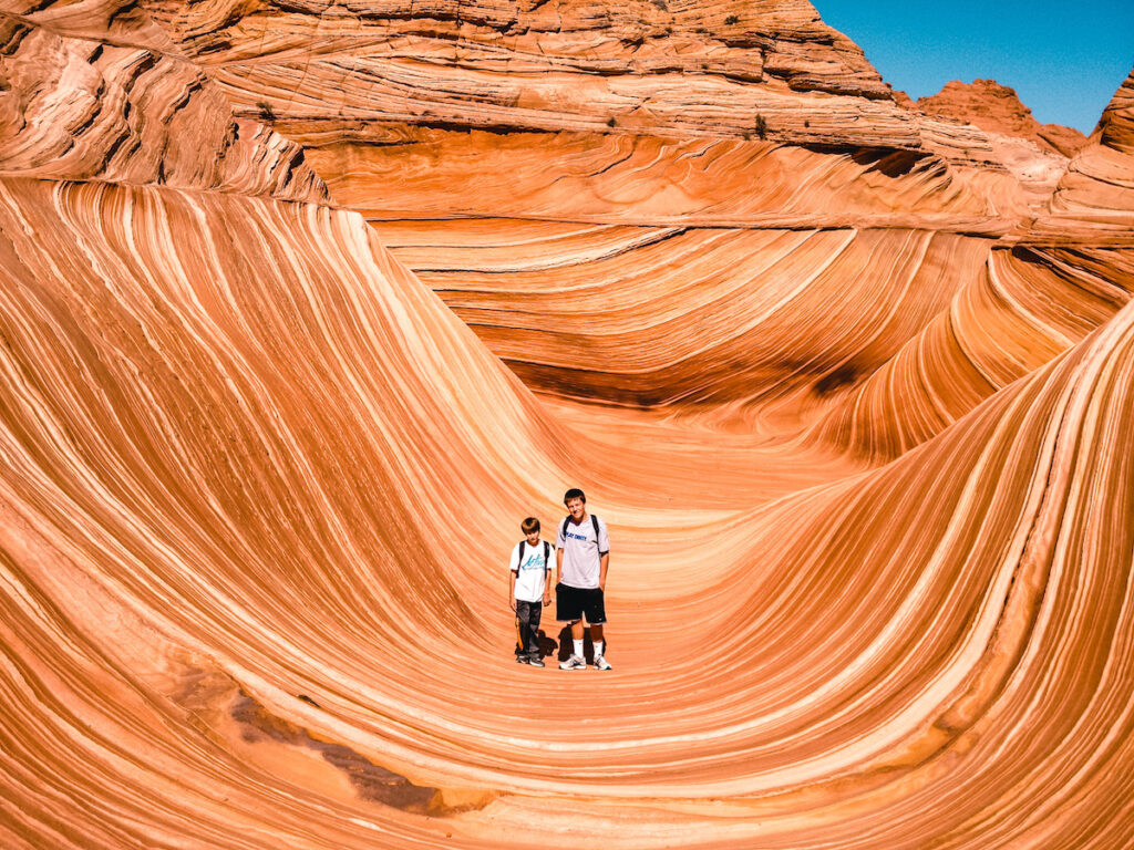
20. The Wave, Border between Arizona and Utah
Recommended by Jenifer from The Evolista
The Wave Hike, on the border of Arizona and Utah, is not only on the best hikes in Arizona, but also one of the most beautiful hikes in the USA.
Located in the Paria Canyon – Vermilion Cliffs Wilderness area, the stunning red sandstone formation was sculpted into the shape of a wave by millions of years of erosion.
It is one of the most photographed natural places in the United States and is an easy contender for the most beautiful hiking in the US.
The 5.2-mile out-and-back hike with 418 feet of elevation gain is harder than it sounds due to lots of soft sand and weather conditions.
Spring and fall are the best times to do the 3-4 hour round trip hike because the temperatures are mild.
Only 64 people are allowed to make the trek per day. 48 people (or 12 groups) can obtain the highly coveted permit in advance in the Wave lottery online.
The other 16 permits (or 4 groups) are awarded at the in-person lottery in Kanab, Utah.
A non-refundable $9 application fee is required to enter the lottery. If you are awarded the permit, you will then pay a recreation fee of $7 per person or dog. You only pay the recreation fee if you are awarded the permit.
While crowds aren’t really a problem because of the permit process, it’s best to set out early so you can get a chance to spend some time at the Wave by yourself.
Pro Tip: This trailhead is the same for Wire Pass, which is a highly popular trail. Show up early to not only beat the crowds at the Wave, but also snag parking.
An early start will also allow you to hike past the Wave to see Melody Arch, which most people miss.
Practical info
Distance: 5.2 miles out and back
Difficulty: Moderate
Elevation Gain: 418 Feet
Estimated Time: 2 – 4 hours
Red Tape: The hike is dog-friendly. Permits are obtained through a lottery system with a $9 application fee, then a $7recreation fee per person or dog, if you get the permit. Parking at the trailhead is $6 per car.
21. Queens Garden and Navajo Loop in Bryce Canyon Nationa Park, Utah
Known as one of the most beautiful national parks in the US, Bryce Canyon is certainly a top hiking destination. Towering red rock spires pierce the pine tree forests to create a winding series of canyons.
One of the most rewarding ways to get in on the action is to hit up one of the best hikes in Bryce Canyon. The Queens Garden and Navajo Loop Trails are a highly popular hike that brings you into the heart of this unique canyon country.
If you’ve only got one day in Bryce Canyon, hit this trail for sunrise and score some solitude in this tranquil landscape. For the best sunrise views, you can hike the loop clockwise, starting in Queen’s Garden.
Follow signs to Navajo Loop as you wind your way down into the heart of the canyon.
Natural bridges, archways, and gravity-defying spires are a feast for the eyes. At the end you’ll have to wind your way up the lung-busting Wall Street section, a series of steep switchbacks that will have you huffing and puffing.
As one of the top things to do in Bryce Canyon, this classic trail does see quite a bit of traffic. The best time to hike is late spring and fall. Summers tend to be too crowded.
Winters in Bryce Canyon are picturesque, but this trail frequently closes due to ice fall.
Practical info
Distance: 2.6 miles
Difficulty: Easy with a few steep sections
Elevation Gain: 623 Feet
Estimated Time: 1.5 to 2 hours
Red Tape: No dogs. The trail closes in winter if there is snow and ice. Fee to enter the park.

22. Bright Angel Trail and the Rim-to-Rim Hike in the Grand Canyon, Arizona
When it comes to Grand Canyon Views, the Bright Angel Trail really delivers. There’s a reason that this is one of the best places for hiking in the US. Simply put, the Grand Canyon is a world icon.
Located on the South Rim of the Grand Canyon, this challenging hikes takes you from the rim of the canyon down to the Colorado River and back.
Most people opt to hike either part of the trail (Indian Garden or Plateau Point are good turn around spots) or spend several nights hiking the rim-to-rim of the Grand Canyon.
The going is steep, water is scarce, and during the hotter summer months there is no shade. Only experienced hikers should attempt the trail in one day, and even then be prepared for a grueling hike.
Practical info
Distance: 15.3 miles out and back
Difficulty: Very challenging
Elevation Gain: 4,748 Feet
Estimated Time: 8 to 10 hours
Red Tape: No dogs allowed. It is a $35 entry fee for the park. Water is scarce and shade is scarcer, come prepared.
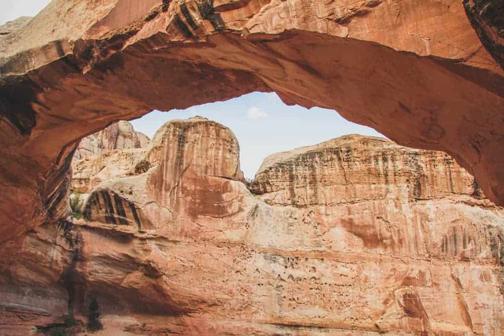
23. Hickman Bridge Hiking Trail, Capitol Reef, Utah
Recommended by Jamie of Photo Jeepers
Utah is home to many amazing national parks. But none are quite as special as Capitol Reef National Park.
Not only is this place highly underrated, but it is home to some of the most incredible hikes in the USA.
And one of the best Capitol Reef hikes of them all is the Hickman Bridge Hiking Trail.
See, this popular trail starts off with some small switchbacks that eventually level out. You’ll then continue along a wash that will lead you up to a fork in the trail.
Along the way, be on the lookout for iconic local landmarks like Nels Johnson Bridge, Cohab Canyon, and Capitol Dome in the distance.
Then, at the fork in the trail, head right and you will eventually come across a bridge. Continue under the bridge and you’ll be rewarded with some of the best desert views in the entire park.
This is also one of the less technically challenging hikes in the Capitol Reef since it’s just under two miles long and features a moderate amount of elevation gain.
Also, like with all the hikes in this amazing park, be sure to stay on the trail, always stand away from cliff edges, and avoid narrow canyons if there is a possibility of a storm in the area.
This hike is also best used between March and November when the weather is at its best. And you can try the Cassidy Arch Trail while you’re here too.
Practical info
Distance: 1.7 miles
Difficulty: Moderate
Elevation Gain: 416 feet
Estimated Time: 1.5 hours
Red Tape: $10 for individuals and $20 for private vehicles. Pets are also allowed in the park but only in designated areas and not on this trail.
Amazing US Hiking Trails: Hawaii
For a tropical, care-free vibe, head to the islands of Hawaii. Getting out on the trails here takes a little bit of prep.
First, you have to contend with the heat and secondly, lava rock. But for those who want to visit truly amazing hiking areas in the US, then Hawaii is the place for you.
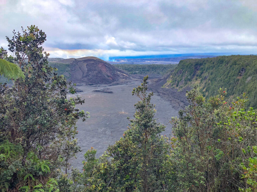
24. Kilauea Iki trail, Hawaii Volcanoes National Park
Recommended by Sarah Vanheel from CosmopoliClan
There is no better hiking destination on Hawaii than Volcanoes National Park. Two active shield volcanoes, Mauna Loa and Kilauea, make up this UNESCO designated Biosphere Reserve and star attraction on the Big Island.
Some of the highlights of this spectacular national park include the Chain of Craters Road, the Crater Rim Drive, the Puʻuloa Petroglyphs, the Thurston lava tube, the molten lava flows and the sulphur banks.
Hawaii Volcanoes NP is also home to some impressive hiking trails that make this one of the best places to hike in the USA.
In fact, the Kilauea Iki trail, that traverses one of the side craters of the Kilauea volcano, is by far the most spectacular one.
The loop trail first leads though the northern rim’s lush rainforest. If the mist doesn’t obscure the views all too much, you’ll be able to see the pit crater from several look-out points.
When the trail descends, it gets rocky and slippery. This is the most challenging part of the hike but it’s well worth the effort.
Standing on the solidified lava lake of an active volcano, with steaming vents and deep cracks, is just sensational. The 4,000 ft elevation of Hawaii Volcanoes NP often results in fog, especially in the morning, and rain, especially in winter.
Always pass by the Visitor Center before you visit to check the latest conditions. Hawaii Volcanoes National Park is located on the south side of the island.
It’s also just a 40-minute drive from the windward coast which makes it a perfect day trip from Hilo.
Practical info
Distance: 3.3 miles.
Difficulty: Moderate
Elevation Gain: 400 feet
Estimated Time: 1 hour 45 minutes
Red Tape: Dogs are not allowed on this trail. Entrance to Hawaii Volcanoes National Park costs $30.00 per vehicle.
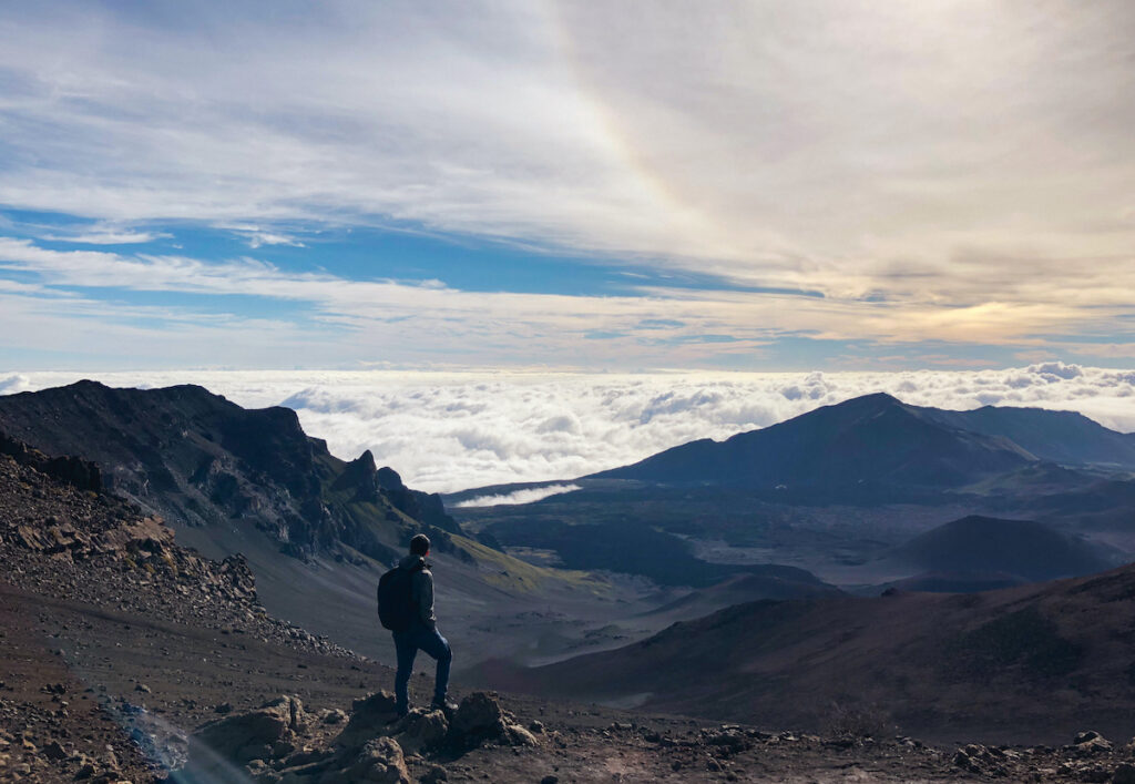
25. Sliding Sands Trail, Haleakalā National Park, Maui
Recommended by Candace from A Journey Inspired
Mount Haleakalā, also known as the East Maui Volcano, is a massive dormant shield volcano with a summit at over 10,000 feet above sea level.
Its stunning landscape is protected by Haleakalā National Park and is home to many rare and endangered species.
Many tourists flock to Haleakalā to view the sunrise or sunset at the summit and to enjoy one of the best places to hike in the USA.
While there are many trails in the summit district, there’s one hike that you must do – the Keonehe‘ehe‘e Trail, also known as the “Sliding Sands”.
The beauty of the Sliding Sands Trail is that it is full of as much adventure as you choose to experience, and it is less-traveled so you won’t be running into many tourists.
You can make the hike as long or short as you like, but the further you descend into the crater, the more life and color (in what seems to be a deserted land) you will discover.
You may even spot the endangered Hawaiian Silverswords, one of the most rare plants in the world!
The hike is rated “difficult”. It’s not for the faint of heart because it is not only long, but also at an elevation that is considered high altitude.
Therefore, you may find yourself short of breath quicker than usual, so use your discretion to determine how far to go into the crater (the way back up will be harder).
It is also easier to become dehydrated or burnt at such a high altitude, so ensure you pack food, water, and sun protection.
Hiking boots are a must, and trekking poles are also useful because the sand literally “slides” under your feet.
Despite being on a warm Hawaiian island, expect this hike to be windy and colder, so wear a waterproof windbreaker as well.
Most importantly, prepare to have your breath taken away by incredible views at this otherworldly destination that is known for some of the most beautiful hiking in the US!
Practical info
Distance:11.0 mile
Difficulty: Difficult
Elevation Gain: 2,795 feet
Estimated Time: 5.5 hours
Red tape: Fee of $30 per vehicle to enter Haleakala National Park through a lottery system, which will provide access for 3 days. Not dog-friendly.
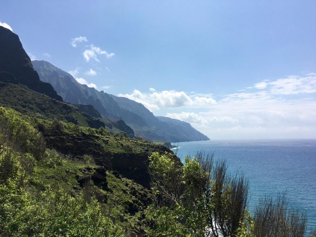
26. Kalalau Trail, Kauai
Recommended by Susan Gleissner from This Big Wild World
The Kalalau Trail wraps along Kauai’s iconic Na Pali Coast for 22 miles through pristine wilderness. It’s one of the most breathtaking places in the world and offers some of the best hiking in the US.
But, along the way, expect to navigate tricky water crossings prone to flashfloods and narrow cliffs since this is one of the best warm places to visit in the USA.
Those who hike the trail are rewarded at the end with Kalalau Beach, which is lined with campsites, waterfalls, and caves to explore for days. It’s also a spectacular place to enjoy the sunset.
Permits are required past mile 2 and must be reserved in advanced. If permits aren’t available, hike the first two miles to Hanakapi’ai Beach and turn inland to visit Hanakapi’ai Falls instead.
The trail has limited shade, so take precautions such as wearing sunscreen, hiking early in the day and carrying plenty of water plus a water filter.
While there are plenty of freshwater sources along the trail, there is a risk of leptospirosis. Consider using a Steripen with prefilter or other purification methods designed to minimize this risk.
The Na Pali Coast wraps along the northwestern edge of the island of Kauai, meaning it is exposed to unpredictable and rapidly changing weather.
Boats and rescue helicopters have limited ability to help hikers stranded in bad weather.
It is best to bring food and supplies for up to 2 extra days just in case. The trail’s narrow ledges and claylike soil make it somewhat dangerous to navigate in wet conditions.
Experienced hikers will enjoy the challenge and incredible beauty of the Kalalau Trail!
Practical info
Distance: 22 miles
Difficulty: Difficult
Elevation Gain: 6,177 feet
Estimated Time: 2 – 3 days
Red Tape: Permits required, 5-day maximum, dogs not allowed.
Catch me on YouTube!
Want more secret backpacking trips? Ultralight hacks that every hiker can adapt? Experience the top outdoor destinations in the world without the crowds? If you want to get insider knowledge of all things outdoors, then you’ll wanna subscribe to my YouTube channel, where I am giving away my DECADES of knowledge as an outdoor professional. I’ll see ya there!
Additional Pro Hiking Resources
Wanna learn how to hike like a pro, not a tourist? Check out these expert hiking resources:
