Last Updated on October 1, 2025 by foxintheforest
From the rocky peaks of the Wasatch Range to the magical red rock deserts of Moab there are plenty of incredible Utah hikes. With so much ground to cover, this list of the best hikes in Utah delivers big views, mesmerizing scenery, and plenty of challenging trails.
From the easy hikes of Arches National Park to hardcore backpacking over petrified sand dunes you’ll find the perfect adventure on these incredible Utah hiking trails.
The red rock deserts are a bit of a second home to me. I spend at least 6 weeks a year here exploring the best of the desert. But with so much ground to cover, I decided to enlist the help of these pro bloggers to fill in a few of the best hikes in Utah I’ve got left to see.
If you’re looking to visit the most amazing Utah hikes without the crowds, then you’ve come to the right place. As a freelance writer for the outdoors, I’m a literal pro at hiking.
Over the years I’ve learned how to successfully beat the crowds on famous trails like Delicate Arch and more.
So keep reading to find out how to enjoy the best hikes in Utah like a local, not a tourist.
About this Guide to Utah Hikes
Inside this guide to the best hikes in Utah you’ll find:
- A list of easy hikes in Utah
- Moderate and challenging Utah hiking trails for avid hikers
- Information about difficulty, length, and where to find each hike
- Tips for hiking in Utah
- Additional Utah hiking resources
The Best Hikes in Utah
This mega list of the best hikes in Utah puts you in the heart of gorgeous natural scenery. Each hike has a unique flavor, and some require advanced permits, so be sure to do your homework before you hit the trails.
Easy Hikes in Utah
These easy hikes. in Utah deliver big rewards for minimal effort. For newbie hikers and those looking for a mellow day, be sure to check out these Utah trails.
Mesa Arch
As one of the easy hikes in Utah, many people flock to Mesa Arch to capture an iconic sunrise over Canyonlands National Park. In fact, visiting Mesa Arch for sunrise is a must-do for any trip to the Island in the Sky district of the park.
Located just 50 minutes from downtown Moab, it’s easy to reach the arch well before the sun comes up.
The trail to the arch takes about 10 minutes to reach, even in the dark, making it one of the simplest Moab hikes. You can’t climb the arch (it’s illegal) but the views are breathtaking.
Watch as the sun pierces the horizon and comes right between an incredible archway overlooking the White Rim Road.
Pro Tip: If you’re headed in with a tripod and want one of the top spots for photography, arrive 90 minutes before sunrise or opt to visit Canyonlands National Park in winter, when the crowds have thinned out a bit.
Mileage: 0.7 miles
Elevation gain: 65 feet
Difficulty: Easy
Estimated Time: 20-minute hike out-and-back
Entry Fee: $30
Permits required? No
Pet Friendly? No
Highlights: Canyon views, La Sal Mountains, and up-close views of the iconic Mesa Arch.

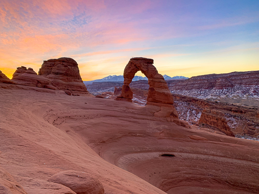
Delicate Arch
Arguably one of the best hikes in the USA, everyone needs to visit Delicate Arch for sunrise at least once. As one of the top hikes in Arches National Park chances are you’ll have company if you don’t come super early in the morning.
This uber-popular trail is absolutely smashed with people since it’s on everyone’s list of things to see on a one-day trip to Arches National Park. During the day lines are common to reach the views. So if you want some solitude, come for sunrise.
You’ll make your way up a small hillside, then over a tall hill of rock until you reach a small mesa. From here, traverse along the well-worn path until you climb a final slab of rock toward Delicate Arch.
If you time it right, you can see the beautiful pinks and reds light up the sky as the arch slowly comes into the light.
Pro Tip: We saw a lot of graffiti here. DO NOT CARVE THE ROCKS. Do your part to Leave No Trace and be a good steward visiting this well-trodden trail.
Mileage: 3 miles
Elevation gain: 610 feet
Difficulty: Easy to moderate
Estimated Time: 1.5 hours
Entry Fee: $30
Permits required? No
Pet Friendly? No
Highlights: Slickrock hill with sweeping views and seeing the arch up-close. There are also opportunities for side exploration (Ute petroglyphs and Wolfe Ranch homestead).
Wire Pass to Buckskin Gulch
One of the best hikes in Utah also happens to be the longest known slow canyon in the world. Enter the famous Buckskin Gulch (over 15 miles long) from the Wire Pass slot canyon entrance along School House Road.
You’ll hike along a wash until the sandy bottom slot canyon starts. Continue inwards down a ladder and into the heart of Buckskin Gulch and one of the best slot canyons in Utah.
At the junction, you can spot petroglyphs and ancient art (along with graffiti – do not add to the graffiti, including the handprints – it’s illegal).
Head right to continue down Buckskin Gulch (go for as long as you like, just remember you’ll need to head back) for a never-ending slot canyon that puts you in another world.
Pro Tip: The left fork is a slot canyon too, but heading right has more intriguing features.
Mileage: 5.6 mi
Elevation gain: 616 ft
Difficulty: Easy
Estimated Time: 4 hours
Entry Fee: $6
Permits required? Yes
Pet Friendly? Yes but there is a ladder to reach Buckskin Gulch
Highlights: The longest known slot canyon in the world
Grand View Point
Another amazing easy hike in Utah, the Grand View Point Trail in Canyonlands National Park is a must-visit. If you’re looking for uninterrupted bird’s eye views of canyon systems, this is it!
Make your way along the easy trail to explore incredible views of the White Rim Canyon, Orange Cliffs, and beyond. Below you’ll see roads that lead to some of Moab’s most scenic drives and catch a glimpse at just how vast this section of desert really is.
If you’re looking to enjoy Arches and Canyonlands National Park in a day, then put the Grand Viewpoint on your list.
Pro Tip: There are no guardrails so be sure to watch your footing and your kiddos!
Mileage: 2 miles
Elevation gain: 32 feet
Difficulty: Easy
Estimated Time: 1 hour
Entry Fee: $30
Permits required? No
Pet Friendly? No
Highlights: A panoramic viewpoint offering a gorgeous view of the canyon system.

Queen’s Garden and Navajo Loop
If you want to get up close and personal with some of the most intriguing scenery in all of Utah, then you’ll want to put Queen’s Garden and Navajo Loop on your list. As one of the premier hikes in Bryce Canyon National Park, you’ll want to hit the trail early to beat the crowds.
Start at sunrise down the incredible Queen’s Garden Trail and see the light filter through the gravity-defying hoodoos, which is one of the most amazing things to do in Bryce Canyon. Make your way along the famous trail, following signs to Navajo Loop and Wall Street.
Sure you’ll be going up Wall Street – a series of switchbacks that wind their way through tunnels in the rock, but it’s worth it for the early morning light.
Pro Tip: If you’re looking to beat the crowds in Bryce Canyon, then certainly hit this trail early in the morning.
Mileage: 2.6 miles
Elevation gain: 623 feet
Difficulty: Easy
Estimated Time: 1.5 to 2 hours
Entry Fee: $35
Permits required? No
Pet Friendly? No
Highlights: A garden of hoodoo sculptures and stunning red rock formations.

Corona Arch
As one of Moab’s best hikes that’s not in a national park, thousands of people per year flock to Corona Arch. As an easier hike, this awesome trail makes its way to the famous Corona Arch. The delicate, tall archway towers out of the side of a cliff.
The trail itself is mostly over slickrock so follow the painted arrows in order to not get lost. You’ll pass Bowtie Arch along the way, an intriguing archway that contrasts greatly from mighty Corona.
There are several steep sections and a ladder, which make this hike a little less dog-friendly than advertised.
Pro tip: Don’t forget to stop at Pinto Arch on the way back (adds 1-mile) for even more fantastic rock formations.
Mileage: 2.5 miles
Elevation gain: 440 feet
Difficulty: Easy to moderate
Estimated Time: 1.5 to 2 hours
Entry Fee: Free
Permits required? No
Pet Friendly? Yes, but not recommended
Highlights: Three gorgeous arches and slickrock walking

Willis Creek Canyon
By Melissa from Parenthood and Passports
Willis Creek Canyon is one of the best slot canyons in Utah for kids. This easy in-and-out hike is located near Cannonville in Grand Staircase-Escalante National Monument. As one of the last areas in the continental US to be officially mapped, Grand Staircase is one of the more remote and lesser-visited areas of Utah.
Even though the hike is almost 6 miles long, hikers don’t have to journey far before they are in the slot canyon surrounded by towering rock walls. A small creek runs through the center of the narrow canyon, so portions of the hike may be dry while others will have a shallow stream that adds a sense of fun and adventure.
As you make your way through the canyon, you will have a blast leaping back and forth across the creek and wading directly through the water. The canyon narrows and widens and even takes you by a small waterfall and an open creek bed!
If you want to hike Willis Creek Canyon, be sure to have an all-terrain vehicle or 4-wheel drive, as the road to the trailhead is bumpy, sandy, and at times, precarious to navigate.
Mileage: 5.8 miles
Elevation gain: 1,227 feet
Difficulty: Easy
Estimated Time: 4 hours
Entry Fee: Free
Permits required? No
Pet Friendly? Yes
Highlights: One of the best slot canyons in Utah

Image courtesy of Melissa from Parenthood and Passports
Sunrise to Sunset Point
By Noel Morata of Oahu Travel Now
One of the best and easiest hikes in Utah is the Sunset Point to Sunrise Point, which is a must on any Bryce Canyon itinerary. What makes this hike so special is the fact that the trail goes through a part of the rim of the canyon and allows you to stop at many gorgeous lookout points for glorious vistas along the way.
If you’re feeling up for the challenge, the short additional hike to Inspiration Point is worth doing for truly spectacular views. You start this moderate hike from the parking area and trailhead to Sunrise Point, which is about 0.5 miles south of the visitor’s center in the park.
You can also get some nice views, sunset skies from Sunset and Inspiration points if you wish to visit in the latter part of the day and enjoy great views and sunset on this side of the park area.
Pro Tip: Sunset Point is actually a spectacular sunrise spot that doesn’t have nearly the number of people at the namesake Sunrise Point.
Mileage: 1.1 miles
Elevation gain: 82 feet
Difficulty: Easy
Estimated Time: Less than one hour
Entry Fee: $35
Permits required? No
Pet Friendly? Yes
Highlights: Bird’s eye view of the amphitheater of hoodoos.

Image courtesy of Ian Morata of Oahu Travel Now
Moderate to Difficult Hikes in Utah
If you’re looking for a little bit more of a challenge, then you’ll want to check out these moderate Utah hiking trails.
Little Wildhorse Canyon/Bell Canyon
For one of the most iconic slot canyons in Utah, be sure to head to Little Wildhorse Canyon and Bell Canyon. This magnificent slot canyon loop features over a mile of wild and wacky sandstone canyon walls. Located in the San Rafael Swell, this is one of the best hikes in Utah featuring desert landscapes.
Minimal scrambling (using your hands and easy climbing) is required to make the journey through this other-worldly landscape. Many people compare this canyon system to the famous Antelope Canyon.
Start the journey going up Little Wildhorse Canyon and come down the beautiful Bell Canyon. In between, you walk across a stunning desert landscape featuring tall red rock walls.
Be sure to check the weather before you go and never enter a slot canyon with rain in the forecast. Flash floods have killed many hikers here so take care.
Pro Tip: Start before 7 am to beat the hordes of crowds.
Mileage: 8 miles
Elevation gain: 787 ft
Difficulty: Moderate
Estimated Time: 4 hours
Entry Fee: Free
Permits required? No
Pet Friendly? Yes
Highlights: Long stretch of narrows you have to scramble through and sculpted rock walls.
Chesler Park Loop
For one of the best hikes in Canyonlands, you’ll certainly want to check out the Chesler Park Loop. Located in the Needles District, you’ll wind your way through an endless sea of hoodoos – or tall rock pinnacles that appear seemingly out of nowhere.
Although the hike is a bit long, overall it’s a moderate lollipop loop that starts along the Elephant Hill Trail and heads towards Chesler Park. If you’re not up for the entire loop, cut over at the Devil’s Kitchen Trail or opt to add in the Joint Trail for the complete loop.
You’ll be slack-jawed from the huge towering rock spires tightly wound into maze-like canyon formations in Chesler Park. The photos don’t really do it justice, but trust me, it’s one of the best hikes in Utah.
Mileage: 10.4 miles
Elevation gain: 1,9820 feet
Difficulty: Moderate
Estimated Time: 6 hours
Entry Fee: $30
Permits required? Permits required for overnight use (recommended)
Pet Friendly? No
Highlights: Canyons, pinnacles, and marvelous canyon views.

Fifth Water Hot Springs
By Victoria Heinz from Guide Your Travel
The Hike to the Fifth Water Hotsprings is a great route for both beginners as well as intermediate hikers. The entire hike takes around 2 hours or 1.5, depending on how fast you go.
The final destination of the trail is, of course, a beautiful set of hot springs. The water is emerald green and crystal clear, making it the perfect place to go for a swim after a long hike. Since they’re natural hot springs, the water is a comfortable temperature and not cold even during the winter months.
Be aware that this trail can get quite crowded on weekends, so coming early (before 7 am) is highly recommended. You can reach the Fifth Water Hot Springs Trailhead in around an hour from Salt Lake City and there is ample parking available.
Mileage: 4.5 miles
Elevation gain: 636 ft
Difficulty: Moderate
Estimated Time: 2 hours
Entry Fee: Free
Permits required? No
Pet Friendly? Yes
Highlights: Emerald green hot springs at the end of the trail
Tower Arch
By Aaren Prody of What Do You Sea
One of the most underrated hikes in Arches National Park and Southern Utah is none other than the Tower Arch Trail. Standing at almost 50-feet tall and 90-feet wide, this arch will make you feel like you’ve landed yourself in one of the most remote parts of Utah that boasts some of the BEST views in the entire state!
This trail is out of the way compared to other trails in Arches, so most people don’t bother to venture down the gravel road to get her. But for those that do, it will remain one of the most memorable hikes on a Utah road trip.
Two miles in, once you arrive at the arch, you’ll be able to climb up onto numerous rock platforms and inside the bowl-shaped arch to look out over an expansive view of Arches National Park. This is a perfect spot to enjoy a sunset in the park with zero crowds. Just be sure to bring your headlamp!
Mileage: 3.4 miles
Elevation gain: 600 feet
Difficulty: Moderate
Estimated Time: 2.5 hours
Entry Fee: $30
Permits required? No
Pet Friendly? No
Highlights: Views of Tower Arch as well as the Klondike Bluffs and lots of other sandstone spires and rock formations.
Observation Point
By Julia Jennings of Well Planned Journey
Overlooking Utah’s popular Zion National Park, you’ll find one of the best hikes in Utah: Observation Point. The strenuous trail is often overshadowed by more popular hikes like Angels Landing, but what many hikers don’t realize is that Observation Point actually provides a better view of Zion (minus the crowds!)
Hikers climb a series of switchbacks past several small canyons to reach the final viewpoint overlooking Zion Canyon.
Pro Tip: The hike is less dangerous and less popular than Angels Landing, making it perfect for those looking to explore Zion away from crowds.
Observation Point can be reached from two trailheads. The most popular trailhead starts at Weeping Rock along the Zion Canyon Scenic Drive and is reachable via the park shuttle. Due to a rockslide, this trailhead has been closed since 2019. The other way to access Observation Point is from the East Mesa Trailhead off the scenic Zion Mt. Carmel Highway.
Mileage: 6.7 miles
Elevation gain: 695 ft
Difficulty: Moderate
Estimated Time: 4 hours
Entry Fee: $35
Permits required? No
Pet Friendly? No
Highlights: One of the best and less-visited views of Zion National Park.

Image courtesy of Julia Jennings of Well Planned Journey
Spooky and Peek-a-Boo Canyon
For an engaging, yet thrilling adventure be sure to check out Peek-a-Boo and Spooky slot canyons in Escalante. Another famous, yet remote trail, this amazing slot canyon duo deliver a lot of red rock fun.
Start at the new Dry Fork Slots Trailhead along Hole in the Rock Road. Then make your way down the drainage, using a GPS and the trail until you come to a basin. To your left is Dry Fork Canyon (a worthy exploration when it’s dry) the middle canyon, blocked by a steep wall, is the famous Peek-a-Boo Canyon.
You’ll need to navigate a few climbing moves to come up the wall in order to enter the canyon. Keep in mind that it’s easier to go up than down, so if you’re intimidated, you’re committed after you make it up the wall.
Continue through the weird and wild canyon until it spills out the back 0.3 miles later. Head east along a path (GPS is helpful since many paths exist) until you reach the entrance to the narrow, Spooky slot canyon.
From here, get prepared to squeeze. You’ll make your way into a narrow, dark canyon that requires you to take off your back and head sideways. A rope guides you on a steep drop further into the canyon until you spill back out into the main basin and hike back towards Peek-a-Boo and out.
Mileage: 3.8 miles
Elevation gain: 633 ft
Difficulty: Easy or Difficult depending on your ability to climb a little.
Estimated Time: 3-4 hours
Entry Fee: Free
Permits required? No
Pet Friendly? No
Highlights: Beautiful waves and contours of the sandstone and getting to test your rock-scrambling skills.
Difficult Hikes in Utah
If you’re up for. areal challenge – try tackling some of the hardest hikes in Utah. From scrambly canyons to long desert jaunts – there’s beauty all around you if you’re willing to work for it.
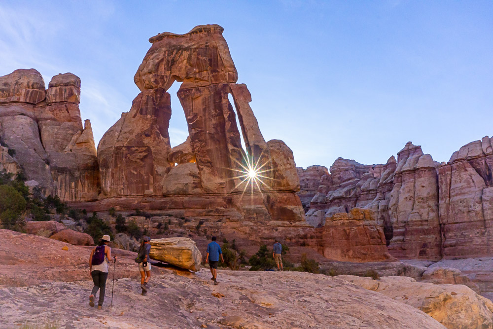
Druid Arch
If you’re interested in backpacking in the Needles District or you want one long, yet rewarding day hike, check out the massive Druid Arch.
Sure, Delicate Arch may get all the love, I personally believe Druid Arch is much more impressive. Located in the Needles District of Canyonlands, you’ll hike quite a ways over some rough terrain to reach this massive 2-tiered archway.
The views are insane along the length of the trail. To reach the arch take the Elephant Hill Trail to Elephant Canyon and then turn at the signed junction to Druid Arch.
The trail gets a little steep and has some exposure, so be prepared to climb a bit and bring sturdy footwear.
Pro Tip: Fall sunset time out for the sun to set directly in between the arch. Pack a headlamp and a GPS for an amazing sunset hike in Canyonlands!
Mileage: 10.4 miles
Elevation gain: 1,614 feet
Difficulty: Moderate to difficult
Estimated Time: 5 to 6 hours
Entry Fee: $30
Permits required? No for day use, yes to backpack
Pet Friendly? No
Highlights: Sweeping canyon views, striking sandstone spires, and Druid Arch.
Reflection Canyon
Reflection Canyon offers a rugged cross-country backpacking route in Utah that delivers big on desert views. There is no real official trail, so be prepared to call upon all of your desert hiking and backpacking skills.
Travel for 90 minutes down the bumpy Hole in the Rock Road until you reach an unmarked trailhead. From here you’ll be traveling off-trail 6 miles to petrified sand dunes. Now you’ll need to use your navigation to reach the iconic Reflection Canyon viewpoint since there are zero trails or markers on the route.
Set up your tent and take care of the cliffs! They are steep and exposed. Catch the sunrise over the canyon for a magnificent desert scene on one of the best hikes in Utah.
Local Tip: There is no water along this trail – you’ll want to pack in at 7 to 8 liters per person for a weekend trip.
Mileage: 16 – 18 miles depending on your route
Elevation gain: 1250 feet
Difficulty: Difficult
Estimated Time: Overnight. 4-5 hours in, 4 hours back
Entry Fee: $35 (although we didn’t need to pay it during our visit, but the ranger station was closed for the pandemic).
Permits required? Yes. Free and unlimited at the Escalante Ranger Station
Pet Friendly? Yes
Highlights: Amazing views of Glen Canyon, Navajo Mountain, and desert scenery.

The Subway
By Carrie Mann of Trains, Planes and Tuk Tuks
Tired of the crowds in Utah’s national parks? Head for Zion National Park’s most epic trail: The Subway.
The Subway got its name from the mysterious slot canyon at its terminus. Walking through the canyon, you’ll feel like you’re in a metro tunnel, which makes the hike phenomenally beautiful the entire way. It meanders through classic red rock country, along a river with heartbreakingly lovely desert waterfalls and wildflowers all around.
However, this trail is not for the faint of heart. It’s not so much a “trail” as it is a 9.1-mile rock scramble/swim.
There is no marked path – you choose your own adventure around and above the boulders on each side of the canyon, or more often, wading and swimming through the river. You’ll have to climb up the sides of waterfalls, so good route-finding skills are essential.
You must have a permit for the Subway hike — and they’re highly competitive. Apply online through the advance lottery on the 5th of the month, two months prior to your trip date (so, May 5th for a July hike, for example).
Only 80 permits are issued a day, and they’re split between canyoneers and hikers, but if you manage to snag a permit, you’ll have Utah’s best hike nearly to yourself!
Mileage: 9.1 miles
Elevation gain: 1,305 ft
Difficulty: Difficult
Estimated Time: 5 hours
Entry Fee: $35 + $5 to apply for a permit
Permits required? Yes
Pet Friendly? No
Highlights: A gorgeous slot canyon, waterfalls, and stunning desert views.

Image courtesy of Carrie Mann of Trains, Planes and Tuk Tuks
Devil’s Garden Trail
By James Ian from Parks Collecting
The Devil’s Garden Trail is the longest hiking trail in Arches National Park. It’s located at the very end of the Arches Scenic Drive – one of the prettiest drives in Moab. The hike is actually divided into three trails and you can do one, two, or all three of them. If you hike all three, you’ll see a total of eight arches, as well as a standing pillar.
The first section is an easy, mostly flat trail that ends at Landscape Arch, which is the longest single-span natural arch in North America. Two additional arches in this section, reached by a short spur trail, are Tunnel Arch (it looks like a tunnel) and Pine Tree Arch (it has a pine tree in the middle of it).
From there, you can go back or continue on to Double O Arch. This section is more adventurous and goes over the tops of a couple of narrow ridges. Side trails go to Partition Arch and Navajo Arch.
At Double O Arch, climb through the smaller lower arch and walk up to a small area where, when you look back, you get a classic view of the two arches, with the park’s famous rock formations seen through the upper “O”.
You can return on the same trail or take the primitive loop trail back to the start. This section is not well marked and requires some skirting around very narrow ledges, and sometimes even wading through water.
Keep a careful eye for cairns marking the trail and don’t hike alone. Private Arch is down a short side spur on this section, which is worth the detour!
Mileage: 7.8 mile loop
Elevation gain: 1,200 feet
Difficulty: Difficult
Estimated Time: 4 hours
Entry Fee: $30
Permits required? No
Pet Friendly? No
Highlights: Some of the best arches as well as secluded views of the park the further you go.

Image courtesy of James Ian from Parks Collecting
Angels Landing
By Zoe of Together In Transit
If you’re looking for a short hike that tests your skills, the perfect route is Angels Landing in Zion National Park. Even though the hike is relatively short, it can get quite challenging.
The hike is fairly easy at the beginning, but once you get past the rest area, you’ll need to climb up a rock using chains and ropes.
Pro Tip: There is a point where there’s barely any surface below you, so make sure you’re okay with heights before attempting this Utah hike.
Once you make it to the top peak, you’ll be rewarded with one of the best vistas of Zion National Park. Make sure to take a seat on one of the rocks to fully soak up the incredible view!
Mileage: 4.4 miles
Elevation gain: 1,604 ft
Difficulty: Difficult
Estimated Time: 2 hours
Entry Fee: $35
Permits required? No
Pet Friendly? No
Highlights: One of the best views of Zion National Park at the end of the trail.
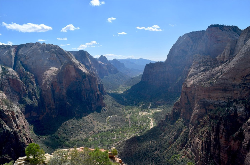
Image courtesy of Zoe of Together In Transit
What should I bring?
Desert hiking demands that you be prepared. This is a harsh environment so be sure to have the following:
- Plenty of water – I like to use a water container for the car. Budget at least 4 liters per person per day, more if you’re out in the summer months.
- Sunscreen, sunhat with a wide brim, sunglasses
- Sunshirt
- First Aid Kit with tweezer (for cacti)
- Noncotton socks
- Breathable footwear that you feel comfortable wearing all day
- Non-cotton shorts for hiking
- Non-cotton, lightweight pants for hiking. Pants protect you against aggravating foliage.
- Non-cotton, breathable t-shirt for hiking (the sun can really beat you up if you wear tank tops, so be aware)
- Electrolyte powder
- A water bladder capable of carrying at least 2 liters of water.
- Salty snacks
- Camera
- Camera clip to strap to your back
- Beanie – the desert can get cold at night so warm clothes are great to have
- Glove liners
- Fleece layer (fall through spring)
- Puffy layer (fall through spring)
- Hiking poles (optional)
- A hiking pack. I love the REI Flash series for something mutli-use and economical
- A toilet kit: shovel, WAG Bag (most national parks require this), hand sanitizer, TP/baby wipes, a small plastic baggy to pack out TP and sanitary items
- Pee funnel – optional
- Pee rag – optional
- A plastic baggy for trash (wrappers, fruit peels, etc). I like to use compostable dog waste bags.
- Headlamp
- GPS navigation
- emergency communication device
- Wind/rain layer
- Pocket knife
NOTE: These are affiliate links. Meaning I get a small kickback from every purchase, no matter the purchase, at no additional cost to you. This is a small way you can show support for my channel and it means a lot, so thank you!
When is the Best Time to Hike in Utah?
With such varied terrain, the best time to hike in Utah largely depends on where you are hiking.
If you’re looking for when to visit Moab and the surrounding desert areas, then you’ll want to hike in either the spring or fall.
Winters are great if you don’t mind the cold since you’ll have the entire place to yourself. Summers are too hot and should be avoided.
Areas such as Escalante, Zion, Bryce Canyon, Capitol Reef, and other top hiking spots in Utah are also best in spring and fall.
Pro Tip: Bryce Canyon National Park can close in bad weather – so avoid visiting in winter if you want to hike Wall Street because it’s typically closed until around April.
For areas such as the Uinta Mountains and the Wasatch Range, you’ll want to hike between mid-June and late September. Temperatures are typically warmer and the threat of snow drifts and avalanches has faded away. Plus, the wildflowers are in bloom too!
Catch me on YouTube!
Want more secret backpacking trips? Ultralight hacks that every hiker can adapt? Experience the top outdoor destinations in the world without the crowds? If you want to get insider knowledge of all things outdoors, then you’ll wanna subscribe to my YouTube channel, where I am giving away my DECADES of knowledge as an outdoor professional. I’ll see ya there!
Additional Utah Hiking Resources
Ready to hike in Utah like a pro? Check out these additional handy resources:
- Expert Tips to Master Desert Hiking
- Camp Like a Pro in the Desert – Here’s How
- Incredible National Parks for Fall
PIN THIS POST

