Last Updated on September 15, 2025 by foxintheforest
A true Indian Peaks classic, hiking South Arapaho Peak needs to be on your bucket list. Stunning scenery along a relatively gentle approach hike, followed by iconic Rocky Mountain views await you on this butt-busting journey.
South Arapaho Peak standard route makes for an awesome first Colorado 13er. For those who seek a real thrill, you can find several classic mountaineering lines with a hassle-free approach. With cool views of the Arapaho Glacier from the summit, any route you choose will deliver you that high-altitude satisfaction.
As a local, I’ve climbed South Arapaho Peak and North Arapaho countless times. In fact, I’ve personally been up every route that’s named on the mountain. The 4th of July trailhead offers a ton of beauty and has something for everyone. If you’re looking to experience South Arapaho Peak like a seasoned pro, then you’re in the right place.
About this Guide to the South Arapaho Peak Hike
Inside this expert’s guide to South Arapaho Peak you’ll find:
- Info on getting to the trailhead
- Practical info about South Arapaho Peak, including details about the standard route
- The famous Arapaho Traverse
- Climbing the Skywalker Couloir
- Info about Arapaho Glacier
- Nearby attractions
- Additional local Colorado hiking resources
Where is South Arapaho Peak?
You’ll find South Arapaho Peak nestled on the easter side of the Indian Peaks Wilderness. More specifically, the easiest way to access the peak is to head to the 4th of July Trailhead which is one of the best Nederland hikes.
To get to the 4th of July Trailhead from Denver, head to Boulder and take Boulder Canyon Road to Nederland. Head past Eldora down the dirt road until it ends.
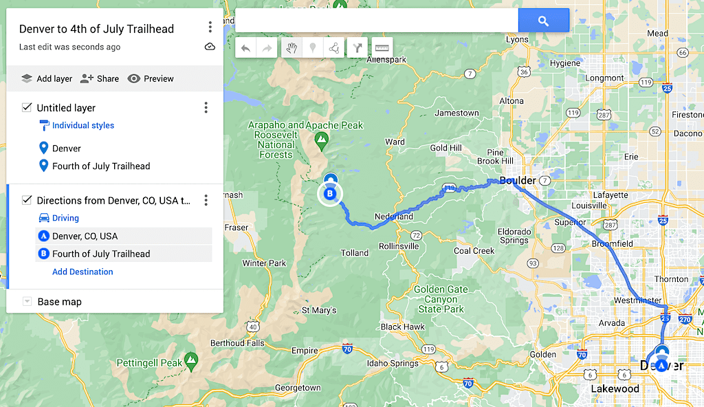
Often touted as a stunning alternative to the tourist-ridden Rocky Mountain National Park, the Indian Peaks Wilderness sees quite a bit of local traffic. The parking area at the Fourth of July Trailhead is quite small, so plan on arriving well before the sun comes up if you want to snag a spot in the summer!
If it’s full, you’ll have to walk from the Hessie Trailhead, which is quite a schlep.
Local Tip: The Fourth of July TH Road is not maintained past the Hessie Trailhead in winter. Typically the road opens mid to late June and closes in early October.
From here, you’ll take the Arapaho Pass Trail to the Arapaho Glacier Trail. Then you’ll turn towards the Arapaho Peak summit.
How High is South Arapaho Peak?
South Arapaho Peak is one of two twin peaks and sits 13,508 feet above sea level. Its twin, North Arapaho Peak is 100 feet higher at 13,608 feet. Since there is less than 300 vertical feet between the two summits, South Arapho Peak and North Arapaho Peak are considered the same mountain from a technical standpoint.
However, a rugged, class 3 and 4 ridge requiring route finding, helmets, and the use of your hands separate the two summits. Therefore, most people opt to just summit South Arapaho Peak, since it’s more accessible.
Local Tip: As one of the top Colorado 13ers, any route up South Arapaho Peak is worth the effort. It’s so beautiful, you’ll get your mountain fix.
South Arapaho Peak Standard Route Map
There are several named routes to the top of South Arapaho Peak. The easiest way to the top is via the standard west ridge. There is a defined trail, with a few deviations and the route itself is largely a steep tundra walk with a few rock hopping sections towards the top.
Reaching the summit of South Arapaho Peak requires a few twists and turns. However, the trails in this area are well-signed and there is a defined trail to the summit.
You’ll start off by taking the Arapaho Pass Trail, then fork at the Arapaho Glacier Trail. From here you’ll gain a ridge, then head up an un-named summit trail (we’ll dive into the details in a second).
Practical Info
Mileage: 8.1 miles round-trip
Elevation Gain: 3,231 feet
Difficulty: Challenging hike, easier mountain summit
Rock Class: 2. This means you will encounter rocky terrain and may occasionally need to use your hands.
Approximate time: 6 hours
Best time to hike: Mid to late June through September
Red Tape? None, but the road does close over winter.
Dog-friendly? Yes on leash, but dogs aren’t recommended due to the rocky nature of the final push.
Do I Need Technical Experience to Reach South Arapaho Peak?
No. You do not. In fact, South Arapaho Peak is an excellent first mountain summit, although it’s not as easy as some of the more popular beginner 14ers in Colorado. It’s challenging, steep, and it’ll take a lot of effort to reach the top. However, unless you are doing one of the mountaineering routes, you won’t need any special gear.
Does South Arapaho Peak Require Scrambling?
No. This is a class 2 hike. Classes of mountain hikes go from class 1 (a dirt path) to class 5 (you’ll want ropes). Class 2 means that you’ll be hopping over big boulders. You may need to use your hands a couple of times to get over something a bit taller, but you definitely aren’t scrambling.
However, for the most part there is a defined path. It wanders, and there are several different ways to go, but if you don’t want to make a single climbing move, it’s certainly possible.
A lot of people call this hike a scramble because it isn’t as easy as other class 2 routes, but this is in no way class 3. I’ve done this hike 4 times at this point and I never use my hands to get to the summit of South Arapaho.
If you’re looking for it and you want to climb one or 2 moves of class 3, there is a social trail that winds its way to a big rock that requires you to use your hands, but it’s by no means required to make it to the top.
How to Hike the South Arapaho Peak Standard Route
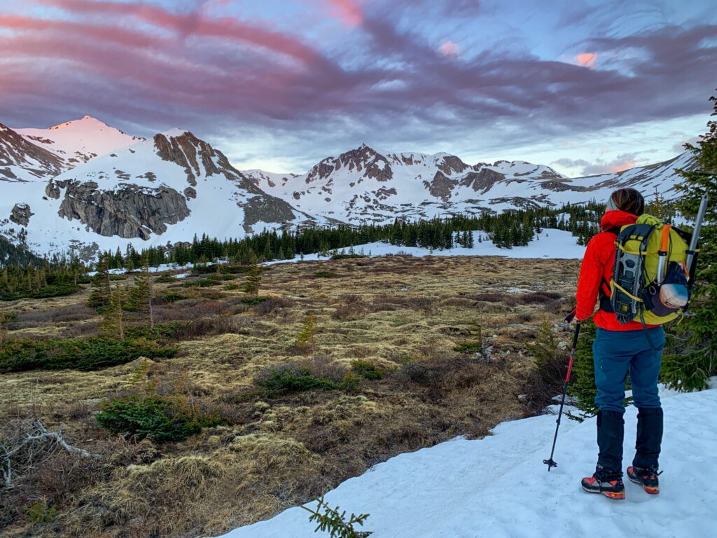
Start off on the Arapaho Pass Trail. The climb starts out in the trees and is a bit steep before leveling off to a gentler grade. Eventually, you’ll push above the treeline and epic mountain scenery awaits you.
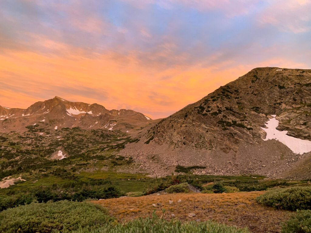
Local Tip: Soak it in! If you time it just right, this is an amazing spot to watch the sunrise!
At 2 miles, you’ll reach a signed junction. Continuing onwards will take you to the top of Arapaho Pass, Lake Dorthy, and Mount Neva (my favorite mountain scramble). But your objective lies to the northeast, along the Arapaho Glacier Trail.
Make your way up the tundra to the Arapaho Glacier Viewpoint. You’ll be able to see the Arapaho Glacier on the backside of the ridge.
From here, head northwest towards the South Arapaho Peak summit. The trail becomes more of a well-worn social trail, with several deviations to choose from. Generally, they are all the same and lead to the same place – a sweet summit with a well-built-up windbreak if you need it.
Come back the way you came to return to your car. One option once you reach the bottom of the saddle between Mt Baldy and South Arapaho would be to make the 0.8-mile detour to the top of Baldy.
Local Tip: Baldy is a sloggy hill walk (a snoozer for someone like me), but if you’re into peak bagging, don’t forget to tag this one!
Continuing on the Arapaho Traverse – North Arapaho Peak
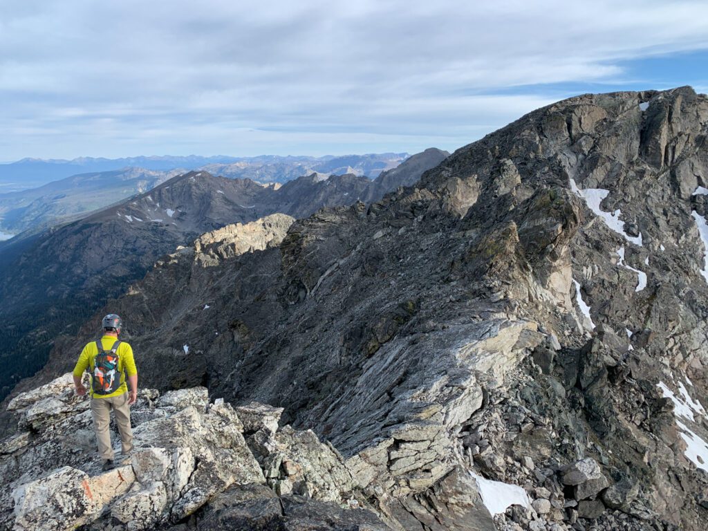
If you’re into scrambling and you want a real thrill, then you’ve got to continue onwards and complete the Arapaho Traverse. This classic class 4 scrambling route is an absolute must-do. The rock is fairly solid and the route will leave you grinning.
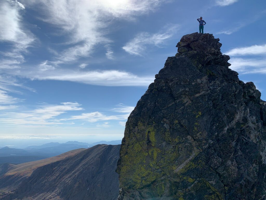
Arapaho Traverse Class 4 Move
There is only one must-do class 4 move on the whole route, but sheesh is it exposed! As an avid alpine climber, I didn’t find it to be that challenging (nearby Neva has a lot more pucker factor), but for the non-climber, it’ll be quite the thrill.
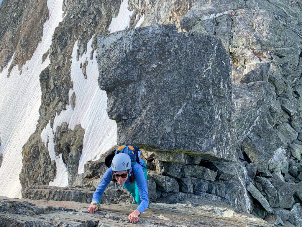
Following this route is simple. Just decent off of the obvious path on the North Side of South Arapaho. You’ll be largely riding the ridge along the west side, bypassing huge spires as you go.
Take the path of least resistance for 0.75 miles. Occasionally you’ll find some yellow painted dots and cairns to mark the way.
There is one move along the ridge proper (see the photo below) that’s class 4 and pretty exposed. It looks worse than it is and there are good toe and foot holds.
Reaching the North Arapaho Summit
After the exposed block, continue until you reach an obviously loose, dirty gully. The rock quality changes and a slip and fall here would be problematic, so pay attention.
After the gully, the terrain levels out quickly for the small, intimate North Arapaho Summit. Enjoy the views, take in the solitude, and head back the way you came.
Local Tip: If you’re an explorer like me, a lot of the spires do go. They venture into upper class 4 and low class 5 in many places and are a bit looser than the solid rock found along the main route.
Required Gear: Helmet
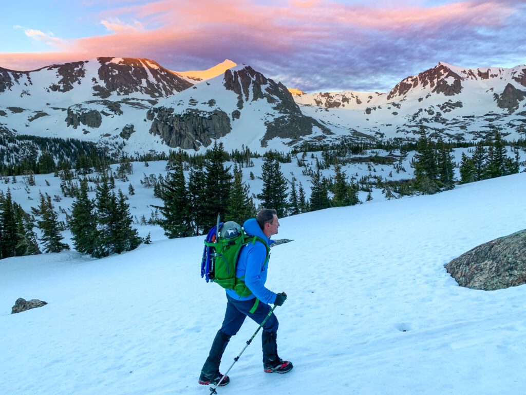
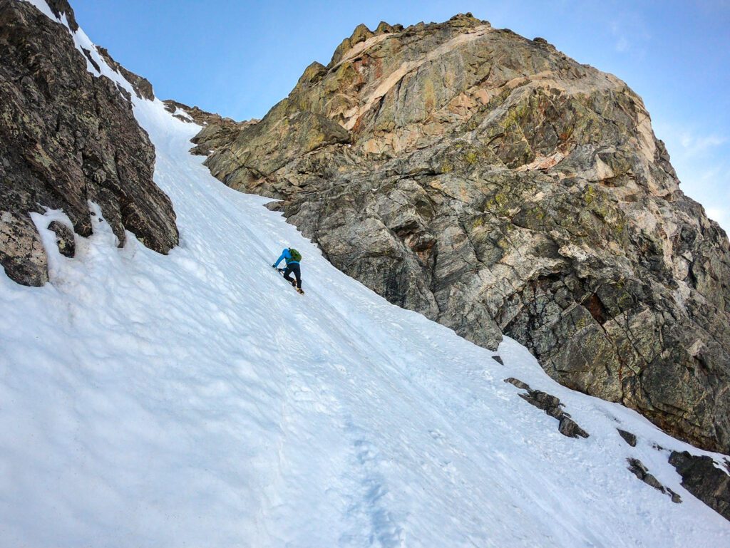
Climbing the Skywalker Couloir
Yet another classic mountaineering line on South Arapaho Peak, the Skywalker Couloir delivers on the adrenaline. It’s the shortest way to the top of South Arapaho Peak, but it’s by far the most technical and challenging.
Round Trip Distance: 5.97 miles
Elevation Gain: 3,263 feet
Difficulty: Extremely difficult. Technical experience required. Seasoned snow climbers and mountaineers only. Depending on the season and your comfort ropes, snow anchors, and rock protection may be required.
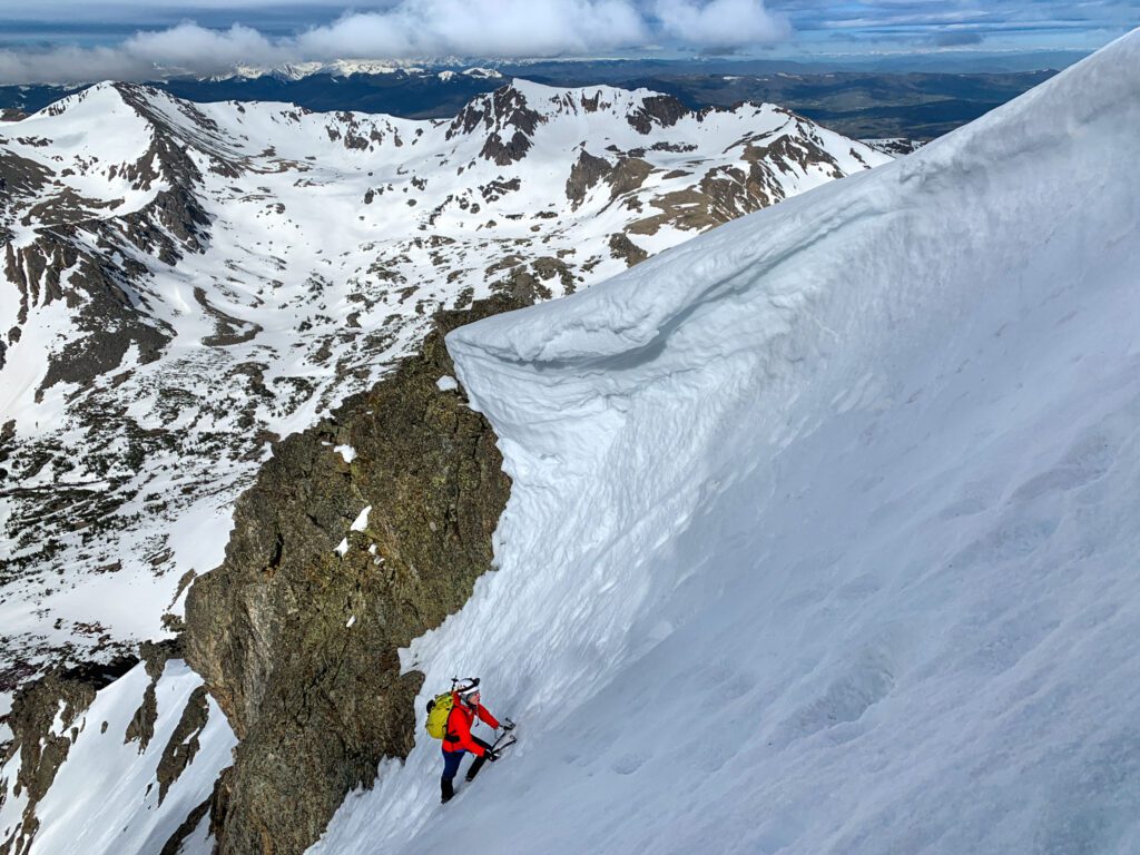
The couloir itself is nearly a half mile long (read: LONG) and has three distinct finishes:
- The Princess Leia Finish: 65-plus degree snow, best done in favorable conditions where the snowpack acts more like ice.
- Han Solo Finish: A Class 4 scramble out of the couloir that avoids the steepest snow and ice, but can be loose. Found on the right side of the couloir, about halfway up.
- The Easy Out: The lefthand side. Avoids the big cornice that can form here. Be aware, that this finish can still get up to 60 degrees.
Once you top out, you’ll still have a little bit of uphill rock hopping to do to gain the summit. Walk off the route via the Standard Route on Arapaho Peak.
Required Gear: Crampons (NOT microspikes), 1 – 2 ice tools or 1 ice ax and 1 ice tool, helmet. If doing the Han Solo finish you may want a handful of cams and nuts as well as rope, since you’ll be rock climbing in mountaineering boots.
Pro Tip: Typically the best time of year to do this climb is rather short – the first couple of weeks in June tend to have the best conditions. Start early to avoid dangerous snowpack.
Where is the Arapaho Glacier?
The Arapaho Glacier can be found on the east side of both South and North Arapaho Peak. It’s a protected area (you aren’t allowed to hike there), as it’s a drinking water source for nearby Boulder.
You’re allowed to hike on the ridge of South Arapaho and the Arapaho Traverse, but going over to the east side of the ridge is technically illegal. Although you wouldn’t want to anyway, it’s just a lot of cliffs and steep gullies with plenty of loose rock.
Is the Arapaho Glacier a Real Glacier?
Technically no. Real glaciers imply ice movement over time and there are no true glaciers in Colorado. What makes Arapaho Glacier a “glacier” is that it has a permanent snowfield. There is snow here year-round.
How Long is the Arapaho Glacier Trail?
The Arapaho Glacier Trail is 7.8 miles one-way and goes from Rainbow Lakes Road all the way to the Arapaho Pass Trail. You can continue past Old Baldy to Rainbow Lakes along the Arapaho Glacier Trail, but you’ll end up miles from your vehicle.
Local Tip: If you want to take the road less traveled to the summit of South Arapaho Peak, it’s a 13-mile, 3,638-foot of elevation gain journey from the Rainbow Lakes Campground to get there.
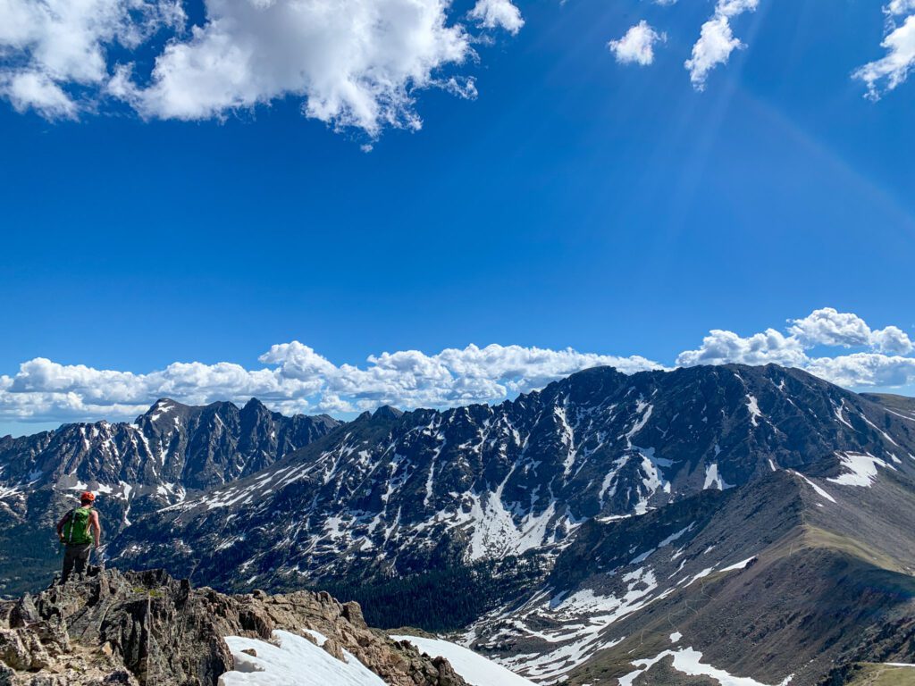
How Many of the Indian Peaks Can be Summited?
Technically, you can summit any mountain depending on how much effort you have. There are 55 peaks and sub-peaks in the Indian Peak Wilderness and all of them can be reached. However, most take an immense amount of effort simply because of access. A few of the most popular mountains to summit in the Indian Peaks Wilderness include:
- Mt Neva (pictured below) 12,814′
- Arapaho Peaks 13,608′ – North Arapaho summit, highest in the Indian Peaks
- Mt Audobon 13,223′
- Navajo Peak 13,409′
- Lone Eagle Peak 11,940′
- Old Baldy 11,340′
- Mt Jasper 12,871′
Tips for Hiking South Arapaho Peak
When it comes to hiking any mountain in Colorado, there are a few tips you’ll want to know. Here’s a look at what to expect.
Summit early. Dangerous monsoon thunderstorms plague the mountains nearly every day in summer. Always use weather.gov to check the weather at your exact location before your hike and plan to be off of the summit by 11 am.
Beat the crowds. This trailhead and summit do get crowded. No, it’s not as bad as say – Mt Quandary – but it is busy here. Go on a weekday or get a sub 5 am start to ensure you’ll beat the crowds.
Pack layers. The mountains can be brutally cold and hot in just the span of a few hours. Always bring a beanie, gloves, puffy jacket, wind/rain layer, and a fleece layer so you’re prepared for changing weather.
Take sun protection. Sunhat, sunshirt, sunglasses, and sunscreen are a must.
Check the avalanche forecast. If you’re taking a more technical route be aware – Colorado has a deadly snowpack. Be sure to check out avalanche forecasts for the area before you go. Even the trail to the standard route crosses through old avalanche paths.
Be prepared to turn around. Summiting a mountain takes a lot of time and energy. Seasoned mountain climbers know that some days just aren’t your day. Don’t push through dangerous conditions, bad weather, or just a day when you’re not feeling up to it. You put yourself and others at risk. No summit is worth your life.
Things to Do Nearby
There are a ton of awesome things to do near South Arapaho. Of course, you’ll find a variety of other beautiful mountain hikes, scrambles, and some of the top backpacking routes in Colorado. A few favorites include:
- Exploring the Hessie Trailhead for some of the best alpine lake hikes in Colorado
- Hanging out in Nederland (known as Ned by the locals) for a post-hike meal
- Spending the day in nearby Rocky Mountain National Park
- Exploring some of the best hikes at the Brainard Lake Recreation Area
Catch me on YouTube!
Want more secret backpacking trips? Ultralight hacks that every hiker can adapt? Experience the top outdoor destinations in the world without the crowds? If you want to get insider knowledge of all things outdoors, then you’ll wanna subscribe to my YouTube channel, where I am giving away my DECADES of knowledge as an outdoor professional. I’ll see ya there!
Additional Colorado Hiking Resources
Ready to hike like a local and not a tourist? I’ve got you covered with this lineup of locally-curated hikes and more:
