Last Updated on September 15, 2025 by foxintheforest
If you’re looking for classic Colorado mountain scenery, look no further than Yankee Boy Basin. This iconically scenic valley delivers a little bit of everything. From gorgeous wildflowers to challenging summit hikes, there’s something here for everyone.
I’ve been to Yankee Boy Basin a few times now and I never get tired of the beautiful surroundings. As a long-time Colorado local of nearly 15 years, I’m on a mission to give you the best local Colorado insights. So if you want to discover Yankee Boy Basin like a local and not a tourist, you’re in the right place.
About this Guide to the Yankee Boy Basin Trail
Inside this local guide to the Yankee Boy Basin Trail you’ll find:
- Practical info for visiting Yankee Boy Basin including road conditions, location, and difficulty.
- A suggested timeline for driving the Yankee Boy Basin Trail
- Things to do at Yankee Boy Basin
- Nearby attractions
- Additional Colorado travel resources
Where is Yankee Boy Basin?
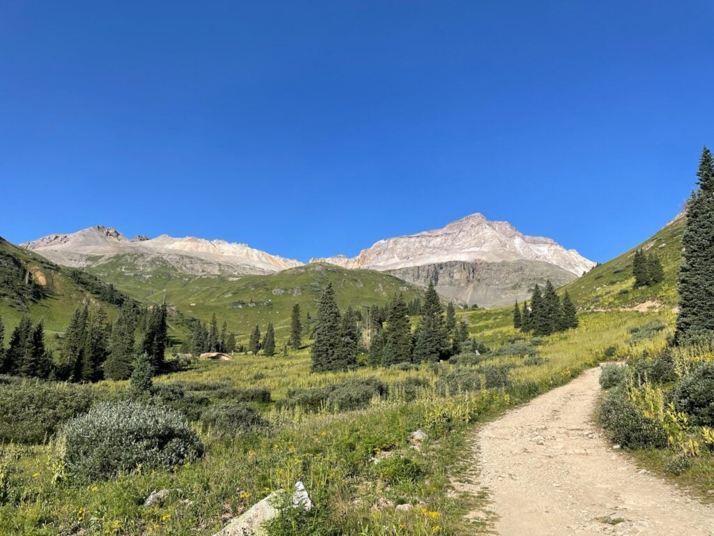
Yankee Boy Basin is a scenic 4×4 trail located just southeast of Ouray, Colorado. Nestled in the heart of the San Juan Mountains, this iconic Colorado destination features wildflowers, hiking, 4×4 driving, and drool-worthy views.
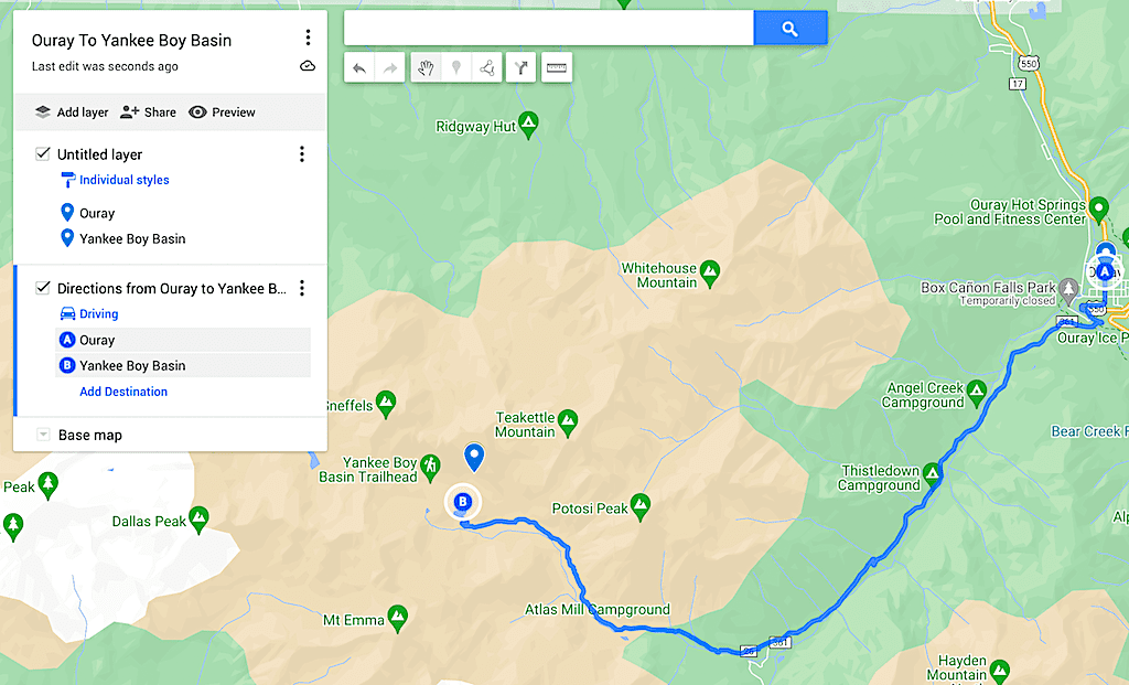
To get here, take 550 or the Million Dollar Highway south out of Ouray, then turn onto Camp Bird Road (near the Ouray via ferrata). The road turns to dirt rather quickly past here. Continue south until you reach a fork in the road and take the right (north) fork onto Yankee Boy Basin Trail.
Is the Road to Yankee Boy Basin Open? Best Time to Visit
Yankee Boy Basin Trail is not maintained during the winter months and is exceptionally dangerous to drive when there’s snow. The winter gate closes shortly after the turnoff from 550 throughout the winter. Always check local conditions before you go (14ers.com road conditions is usually up-to-date).
The best time to visit Yankee Boy Basin is between late June or early July through September. July is wildflower season and the blooms here are spectacular.
Local Tip: As one of the top things to do in Ouray, Yankee Boy Basin gets crowded during the summer months – especially on holidays and weekends. If you want to visit with fewer crowds, consider an early start.
How Difficult is Yankee Boy Basin?
The trail itself is not too difficult. Most people rate it as a moderate 4×4 road (or a tedious road hike if you’re walking). The road gets a 2.5-difficulty rating and reaches an elevation of over 12,500 feet.
If you want to make it all the way to the Atlas Mine, you’ll need a short wheelbase, 4WD, good clearance, and careful driving.
Visitors who are afraid of heights might not like parts of this road. There are sections where there are steep drop-offs and overhanging rocks. However, as far as 4×4 roads go it’s pretty wide. Compared to other 4×4 roads in the Ouray area, this one is relatively tame.
Do I Need a 4WD Vehicle for Yankee Boy Basin?
This answer is a little complicated. In short, it depends. The road starts off as a graded, mellow dirt road. Then turns into a bumpy shelf ride. A hybrid SUV could easily make it to the lower Mt Sneffels parking area.
Past the pit toilets at the lower Mt Sneffels trailhead, the road quickly requires more clearance and power than your average SUV. You’ll need a capable 4×4 vehicle (think 4Runner or Wrangler) past this point as it only gets more difficult the further up you go.
If you plan to drive the entirety of the road then you’ll certainly want a 4WD vehicle with solid tires and a short wheelbase. We have a stock 4Runner on BF Goodrich AllTerrains and didn’t have any issues. We did need 4 low and some careful navigation through steep, rutted obstacles.
However, our friend had a lifted Tacoma with well-loved AllTerrains and couldn’t make it up some of the steep sections. The longer wheelbase was an issue, as were the tires. He parked right below the Wright Lake Trailhead.

How Long Does it Take to Do Yankee Boy Basin?
As an 18.6-mile out-and-back route, the Yankee Boy Basin trail takes around 2 hours to complete. This includes plenty of time to stop and drool at the stunning scenery. It makes for a great intro to a fun-filled day out in the San Juans.
There is a small detour down to Wright Lake that’s well worth the detour, but the road in and out can be a bit rugged.
Local Tip: Plan for extra time if you want to hike Mt Sneffels or to the top of Blue Lakes Pass.
Things to Do at the Yankee Boy Basin
As one of the top scenic drives in Colorado, there are a variety of amazing things to see and do while exploring Yankee Boy Basin. Here’s a look at a few stops and excursions along the way.
Climb Mt Sneffels
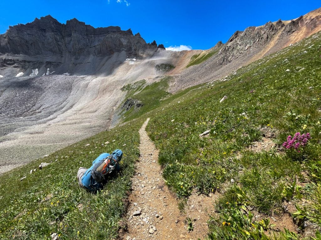
Arguably the most popular thing to do in the basin, Mt Sneffels is a difficult, class 3 mountain climb that starts at Yankee Boy Basin. As one of Colorado’s 14ers, it sits at an elevation of 14,159′.
Local Tip: If you’re hiking Mt Sneffels in the summer start early as violent, dangerous thunderstorms plague the area every day in the summer.
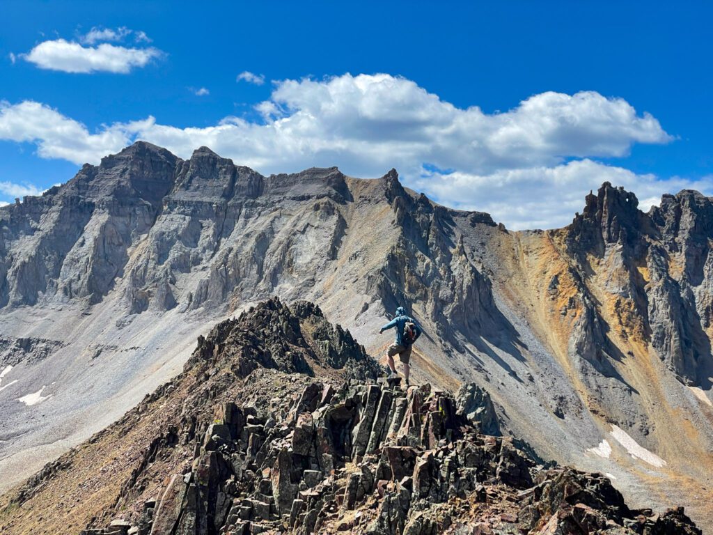
The lower trailhead (where most people start) is 5.57 miles and 2,749 feet of gain. From the upper trailhead, it’s 2.6 miles round-trip and 1,591 feet of elevation gain. The route is semi-technical, meaning it’s a scramble, not a hike. You’ll need a helmet and a lot of stamina to make it to the top.
Local Tip: This route has plenty of loose rock in a gully. Be sure to wear a helmet, as active rockfall is quite common. If you let a rock fly down, be sure to yell “rock” to people who may be climbing below you.
Hike or Drive to Wright’s Lake
Steep slogs up a loose rock gully not your thing? Then hike to Wright’s Lake. There is a small parking area just beyond the Mt Sneffles Lower Parking Lot. Park here (4×4 required) and hike the 2.7-mile easy out-and-back trail to Wright’s Lake. It’s a scenic detour that’s worth the effort.
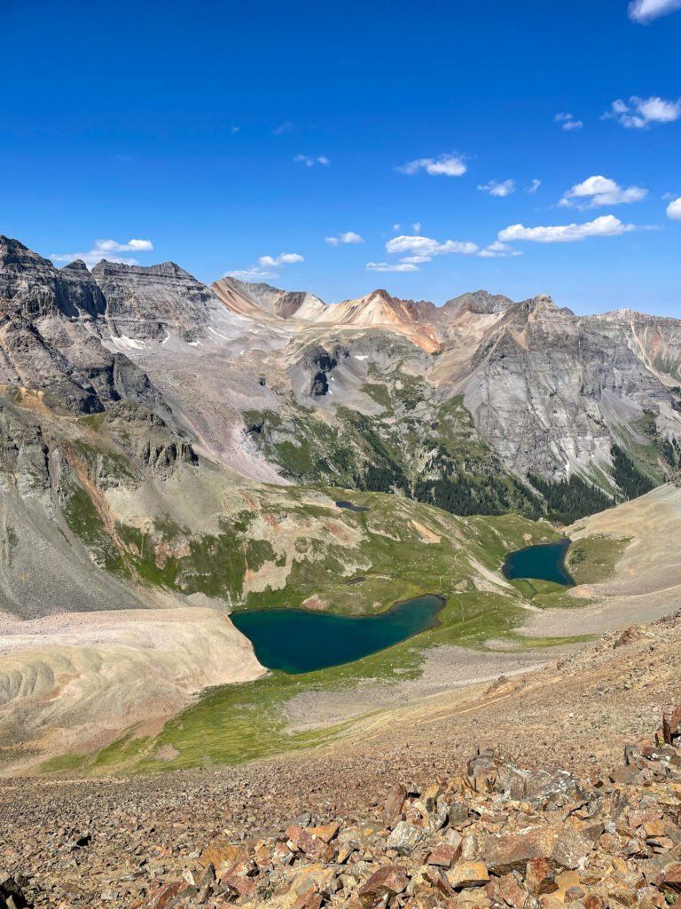
Hike to Blue Lakes Pass
If you’re feeling motivated, after you reach Wright’s Lake, continue up the trail around the lake all the way to the top of Blue Lakes Pass.
Here you’ll get stunning views of Blue Lake, one of the top mountain lake hikes in Colorado. You can continue all the way to Blue Lake, but you’ll have to re-ascend the pass on the way back.
From the Wright Lake Parking lot, it’s a 5.2-mile out-and-back journey with 1,695 feet of gain – moderate by Colorado standards.
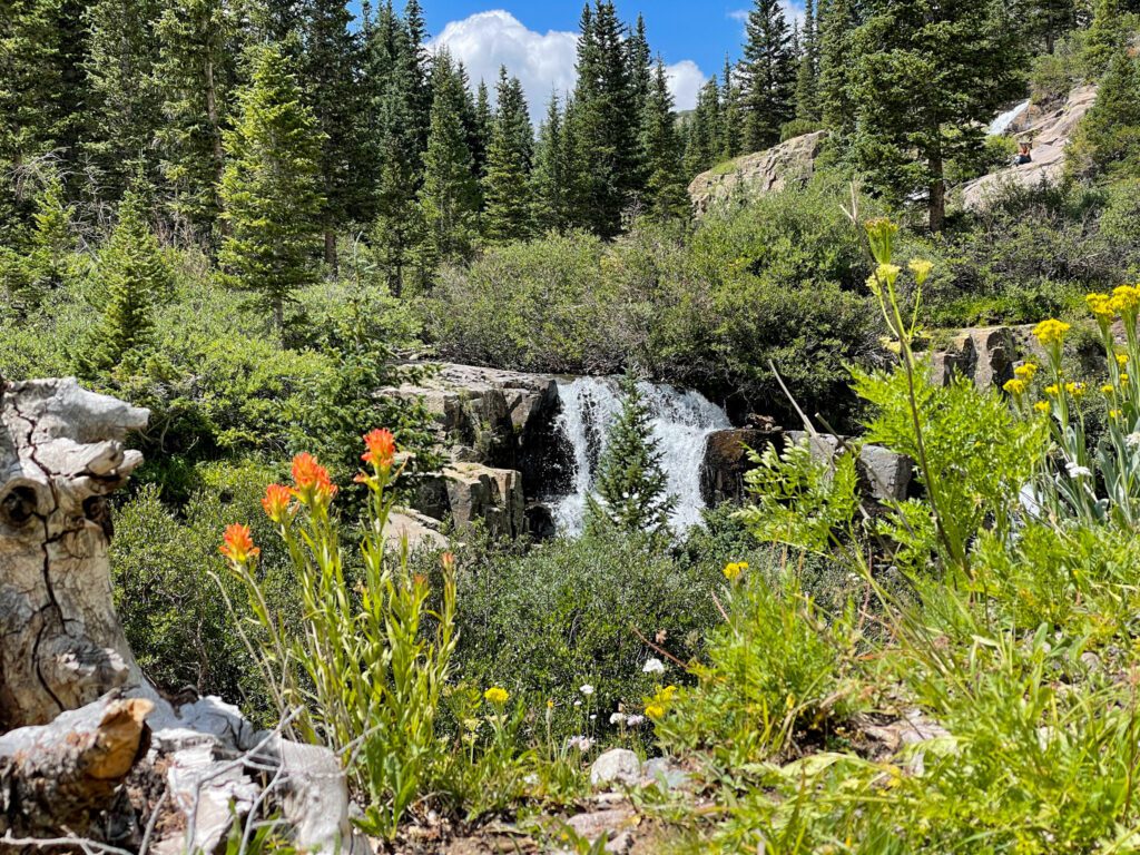
Spot Twin Falls
Along the way you’ll see a small signed turnoff on the left-hand side of the road that heads to Twin Falls. This small, but beautiful Colorado waterfall is well worth a stop. Personally, I found the wildflowers near here to be exceptionally enjoyable.
Take in the Mountain Scenery
There are so many stunning peaks located in the Yankee Boy Basin. Potosi Peak, Teakettle Mountain, Cirque Mountain, Stony Mountain, Gilpin Mountain, and Mt Sneffels are just a few of the stunning rugged mountains you’ll see along the way.
Photograph Wildflowers
Yankee Boy Basin offers up some of the best wildflower viewing in the state. It’s especially popular because you don’t need to hike for miles on end to get there.
This area provides plenty of opportunities for amazing photography. You literally can’t go wrong along the road. Time your trip just right by aiming for a visit from late June through early August.
Check Out The Atlas Mine
Be on the lookout for the Atlans Mine. An abandoned mine located up a steep slope, this old relic of the past is quite impressive to see. I’m not a huge mine ruins person, but wondering how they lugged all of that material up that hillside left me in awe.
The mine is located a few minutes past the Camp Bird and Imogene Pass turnoff, right before the Atlas Mill Campground.
Camping at Yankee Boy Basin
Due to its popularity, you are only allowed to camp at designated campgrounds near Yankee Boy Basin. There is no dispersed camping and violators will be fined. These are some of the top campgrounds near Ouray, so be prepared to share space. Nearby campgrounds include:
- Thistledown Campground
- Angel Creek Campground
Campgrounds are run by the National Forest Service and offer basic amenities such as picnic tables, a fire ring, and vault toilets. You are expected to pack out your trash, so come prepared. They cost $10 a night and are available on a first-come-first-served basis.
Tips for Visiting Yankee Boy Basin
Want to visit Yankee Boy Basin like a local? Keep these top tips in mind.
Get an early start. Jeep tours tend to set out mid to late morning here. So to avoid the rush of people, plan on starting between 7 and 8 am – especially on weekends. Make it fun. Pack your camping stove and bring some breakfast (we really enjoyed making burritos as the sun peaked over the mountains).
Plan for thunderstorms. Near-daily thunderstorms roll in almost every afternoon. Every year hikers get caught in lightning storms. Hail can damage vehicles and make driving conditions slick. If you’re hiking, it means you’ll want to be back to your car by noon. There is no storm cover for most of the Yankee Boy Basin.
Pring plenty of water and sun protection. You’re up there in altitude. Be sure to bring plenty of water and sun protection.
Watch your pup’s feet. This is a dog-friendly activity. But you are expected to clean up after your pet. Not to mention the higher-up hikes have plenty of small sharp rocks that can cut Fido up quickly. Bring paw wax and a first aid kit to protect your pup.
Fires are not allowed outside of designated fire rings. This is a fragile environment that’s prone to wildfires. No open flames except gas-powered stoves outside of campground fire rings.
Nearby Attractions
Looking for things to do nearby? Well, you’re in luck. There are plenty of awesome things to do nearby. A few of my favorites include:
- Taking an OHV through the Alpine Loop
- Hiking to Ice Lake
- Supping at Ridgeway State Park
- Driving Black Bear Pass, Imogene Pass, or Ophir Pass to Telluride
- Driving the Million Dollar Highway for sunrise
Catch me on YouTube!
Want more secret backpacking trips? Ultralight hacks that every hiker can adapt? Experience the top outdoor destinations in the world without the crowds? If you want to get insider knowledge of all things outdoors, then you’ll wanna subscribe to my YouTube channel, where I am giving away my DECADES of knowledge as an outdoor professional. I’ll see ya there!
Additional Local Colorado Travel Resources
Looking to explore even more of Colorado’s famous mountain beauty? Check out these local resources:
- Everything You Need to Know About Visiting Telluride in Summer
- Your Complete San Juan Skyway Itinerary (coming soon)
- Amazing Wildflower hikes in Colorado
