Last Updated on September 9, 2025 by foxintheforest
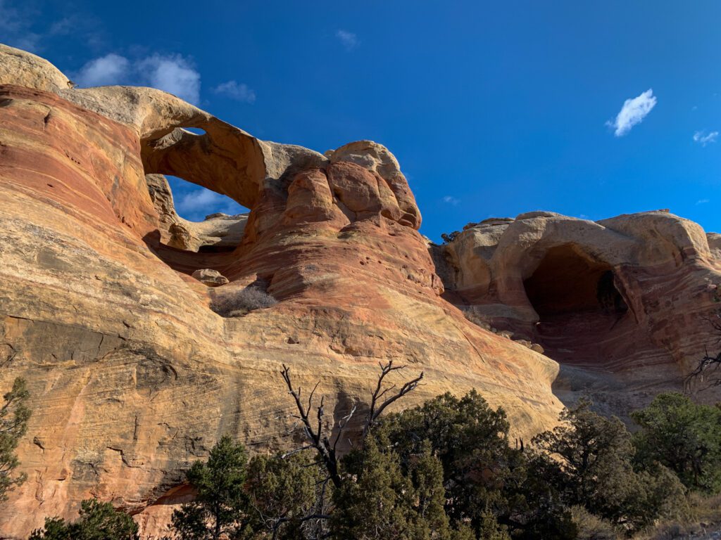
Who knew Colorado had such fantastic sandstone arches? The Rattlesnake Arches Canyon Trail is home to 6 magnificent red rock arches that will transport you into a desert dream. The expansive Rattlesnake Canyon near Fruita is a totally secret landscape – you’d never know it was there unless you visited!
The hike to Rattlesnake Arches is one of my favorite Colorado hikes. It’s truly unique – and definitely not the first thing you think about when you think about Colorado! I adore this route because you get some of that sweet desert scenery without having to drive deep into southern Utah.
I’ve lived in Colorado for 15 years and I have been published widely throughout the outdoor space (think REI, Outside Magazine, and more). As a literal pro at hiking and exploring Colorado, you’ll get the inside scoop about how to visit Rattlesnake Arches like a local, not a tourist.
About this Guide to Rattlesnake Arches
Inside this expert guide to Rattlesnake Arches Canyon, you’ll get insider info on:
- Accessing Rattlesnake Arches via both distinct routes
- Info on the best time to hike
- Practical logistics you need to know for a successful hike including mileage, difficulty, and more.
- Additional things to do in nearby Fruita
- Hiking tips and a quick packing list to get organized
- More drool-worthy Colorado adventures to check out

How Do You Get to Rattlesnake Arches?
There are two ways to get to the Rattlesnake Arches trail. The first is a long day (14.3 miles) via the Pollock Bench Trail. For a more adventurous way in, you can take the Black Ridge Access Road (4WD, high-clearance required).
I’ve done both, and personally, I recommend Pollock Bench if you don’t have any 4×4 driving experience. The hike may be longer, but you’ll get to enjoy a lot more desert scenery.
When is the Best Time to Hike?
The Colorado National Monument and McGuinness National Recreation Area are best accessed from mid-October through mid-April. Temps in the summer are sweltering hot, making this hike quite a challenge.
Winters do get quite chilly, but it’s nice to hike on a sunny winter day in the desert since you won’t have to contend with heat. Fall is typically slightly drier and less windy than spring.
Personally, I love to hike in this area from late October through November.
As one of the top hikes in Grand Junction and Fruita, this trail does see some traffic. So if you want a lot of solitude, I suggest hiking early in the morning to be one step ahead of the crowds.
We started off at 7 a.m. on a Saturday in November (both hikes) and didn’t see a single soul until we were headed back.

Practical Info
Here’s a look at various hiking stats and info for both routes to Rattlesnake Arches.
Pollock Bench
Round-Trip Distance: 14.3 miles (we clocked 14.8)
Elevation Gain: 2,542 feet
Difficulty: Difficult
Estimated Time: 7.5 hours
Dog Friendly? yes, if you’re dog is comfortable with short scrambles or you are able to lift/lower your dog down small cliffs (4-5 feet)
Red Tape: No camping within 1/4 mile of the Rattlesnake Arches Trail
Highlights: Beautiful red rock desert scenery, stunning, expansive canyon views. No 4×4 vehicle required. Access is open year-round.
Lowlights: Long trail with a decent sloggy section in the middle-end. Also harder to add a stop to the top of Rainbow Arch. No shade. No water.
Black Ridge Access
Round-Trip Distance: 5.4 miles including a trip to the top of Rainbow Arch
Elevation Gain: approximately 700 feet
Difficulty: Moderate
Estimated Time: 2.5 to 3 hours
Dog Friendly? Yes.
Red Tape: No camping. $25 fee to access the road.
Highlights: Beautiful red rock desert scenery, stunning, expansive canyon views. The chance to stand on top of an arch.
Lowlights: The road is a bumpy, slow-going slog and takes over an hour. 4WD, high-clearance required. No shade. No water. Entry fee required. The road is not open year-round.
How Long is the Rattlesnake Arches Trail?
The Rattlesnake Arches trail proper is 5.2 miles one-way. You will only do the entire trail if you come from the Pollock Bench Trail. If you’re taking the 4×4 road, you’ll spend 4 miles on the Rattlesnake Arches Trail.
The Rattlesnake Arches Canyon Trail via Pollock Bench
If you don’t want to spend an hour plus driving down a 4×4 road, then access Rattlesnake Arches via the Pollock Bench Trail just outside of Fuita.
From downtown Fruita, head south on Highway 340. Then turn right (west) onto Kingsview Road. Continue down the road (it will change to Horsetheif Canyon Road) and you’ll reach a sign for Pollock Bench. The road turns to dirt, but it’s well-graded.
You’ll find a pit toilet at the trailhead. Parking is free and there is no fee.
Reaching the Rattlesnake Arches Trail
From the Pollock Bench Trailhead, the route isn’t entirely clear the whole way. You’ll follow signs for P1, eventually diverting at the R1 trail junction. Most junctions are signed, but you’ll want a GPS.
Your first obstacle is to gain a sandstone bench. You’ll ride the bench for almost 5 miles before dipping into your first canyon. It’s easy to lose the trail here, and there is one short scramble section, but your objective is to make it to the bottom of the canyon.

Local Tip: If the terrain feels loose and untracked, it probably is. Having a GPS makes navigating the slick rock much easier, so come prepared.
There’s a subtle split in the trail here, but you want to head low and stay on the northwest trail (which is now the Rattlesnake Arches Trail).
From here, you’ll wander through some desert terrain, eventually going up and over the canyon walls – bypassing a bend in the canyon.
You’ll drop back into the canyon and follow the drainage until you reach another junction heading up and out of the Canyon. This is an ancient trail used by the Ute People along their migratory route.
Local Tip: This is a long route, with no shade and no reliable water source. Bring plenty of water, sun protection, and salty snacks.
The going is steep and you’ll round a big mesa, eventually reaching a gentle grade that snakes around a bigger bench until turning back around and heading south into Rattlesnake Arches Canyon.
Reaching Rattlesnake Canyon Arches via the Black Ridge Access Road
If hiking 14-plus miles doesn’t sound like your thing, and you are a competent 4×4 driver with experience in desert driving, then the Black Ridge Road access point might be your ticket to fun.
This rugged road requires 4WD and a high-clearance vehicle. Expect sharp rocks, ruts, deep sand, and a few benches to navigate.
Local Tip: Be prepared! A tow out here will cost you $1,500 and help is hard to find. Don’t expect cell service and travel with an emergency beacon.
To reach the trailhead, you’ll need to head into the Colorado National Monument ($25 fee or free with an America the Beautiful Annual Pass) via Rim Rock Drive from Fruita.
At mile 16.5 turn right at the Glade Park Store sign. After 0.2 miles, turn right on the Black Ridge Access Road. There will be a sign with a gate, be sure to read up and check out the map for more clarity. From here, the road gets rugged and continues to get worse as you go along.
There are two roads that are open during different times of the year. But keep in mind that both roads are closed to motorized traffic from February 15 – April 15.
- The Lower Road is open from August 15 to February 15
- The Upper Road is open from April 15 to August 15
- DO NOT ATTEMPT travel if rain is or has recently been in the forecast. Roads are impassible and dangerous (you can always check in with the local BLM office to get updated conditions).
Local Tip: This 13-mile stretch of road is rugged no matter which route you drive. Expect drive times from here to take one hour.
Hiking to Rattlesnake Arches via Black Ridge Access
From the trailhead, you’ve got two options. The first is to hike on top of the bench for a 3.2-mile round-trip hike. This trail puts you on top of Rainbow Arch, which is pretty cool.
However, if you want the best views of the arches, then I would recommend starting by taking a right (head north, downhill) at the trail junction. This downhill slog meets up with the flat-ish, mesa hike described in Pollock Canyon, You’ll want to head northwest (left) at the junction.
It’s 2 miles one way to snake around into Rattlesnake Arches (ya, I just did that) and end up at the impressive Cedar Arch.
If you still have some hiking energy left, then you should absolutely hike to the top of Rainbow Arch.
Local Tip: You can also hike to Rainbow Arch from Pollock Bench, but it will add about 2.8 miles RT to your 14-plus-mile hike.
Can You Camp at Rattlesnake Arches?
No. It’s a shame because you used to be able to (it was one of my favorite Colorado backpacking trips back in the day). You can’t overnight park at the Black Bench Access road and you cannot camp within 1/4 mile of the Rattlesnake Arches Trail or along the trail.
So if you want to backpack, you must camp along the Pollock Bench Trail. There is no water, so expect to haul it all in with you.
What is the Largest Arch in Colorado?
Cedar Tree Arch is the largest arch in Colorado – at 76 feet across and an opening 43 feet wide. It’s pretty impressive, not quite as grand as some of the Arches National Park landmarks, but it definitely feels on par with the arches you see in the famous Utah landmark.
Tips for Hiking in the Desert
Hiking in the desert is a whole new ball game if you’re not acclimated to it. Be sure to keep the following quick tips in mind.
- Always carry a GPS track of the route. Slickrock trails are not well marked.
- Bring plenty of sun protection (sunscreen, wide-brimmed hat, sun shirt, and sunglasses).
- Pack plenty of salty snacks and bring at least 3 liters per person for this hike.
- Don’t bust the crust! The black, rigid soil is alive and an integral part of keeping desert erosion at bay so plants can root. Step around this cryptobiotic soil.
- Pack a first aid kit with tweezers for unexpected cacti encounters

What to Pack
Hiking in the desert requires a special kit. Here’s what you should bring on your desert hike:
- Plenty of water – I like to use a water container for the car. Budget at least 4 liters per person per day, more if you’re out in the summer months.
- Sunscreen, sunhat with a wide brim, sunglasses
- Sunshirt
- First Aid Kit with tweezer (for cacti)
- Noncotton socks
- Breathable footwear that you feel comfortable wearing all day
- Non-cotton shorts for hiking
- Non-cotton, lightweight pants for hiking. Pants protect you against aggravating foliage.
- Non-cotton, breathable t-shirt for hiking (the sun can really beat you up if you wear tank tops, so be aware)
- Electrolyte powder
- A water bladder capable of carrying at least 2 liters of water.
- Salty snacks
- Camera
- Camera clip to strap to your back
- Beanie – the desert can get cold at night so warm clothes are great to have
- Glove liners
- Fleece layer (fall through spring)
- Puffy layer (fall through spring)
- Hiking poles (optional)
- A hiking pack. I love the REI Flash series for something mutli-use and economical
- A toilet kit: shovel, WAG Bag (most national parks require this), hand sanitizer, TP/baby wipes, a small plastic baggy to pack out TP and sanitary items
- Pee funnel – optional
- Pee rag – optional
- A plastic baggy for trash (wrappers, fruit peels, etc). I like to use compostable dog waste bags.
- Headlamp
- GPS navigation
- emergency communication device
- Wind/rain layer
- Pocket knife
What to Do Nearby
There are plenty of awesome things to do in Grand Junction and Fruita. A few of my favorites include:
- Snagging a pizza at the Hot Tomato
- Going for a sunset drive of the Rim Rock Road in the Colorado National Monument
- Mountain biking the Kokopelli Trail System
- Climbing Ottos Route in the Colorado National Monument
Where to Stay
I’ve stayed in Fruita many times over the years. I typically go for a VRBO if I’m in the area, simply because I like to have a kitchen. If I’m not toting my toddler around and it’s a quick stay, I love the Balanced Rock Inn. It’s convenient, clean, and reasonably priced!
Free BLM camping is pretty hard to come by, and not that great if I’m honest, so you’re better off looking at reserving a spot in Rabbit Valley (Knowles is great) or the Saddle Horn Campground at the Monument.
Catch me on YouTube!
Want more secret backpacking trips? Ultralight hacks that every hiker can adapt? Experience the top outdoor destinations in the world without the crowds? If you want to get insider knowledge of all things outdoors, then you’ll wanna subscribe to my YouTube channel, where I am giving away my DECADES of knowledge as an outdoor professional. I’ll see ya there!
